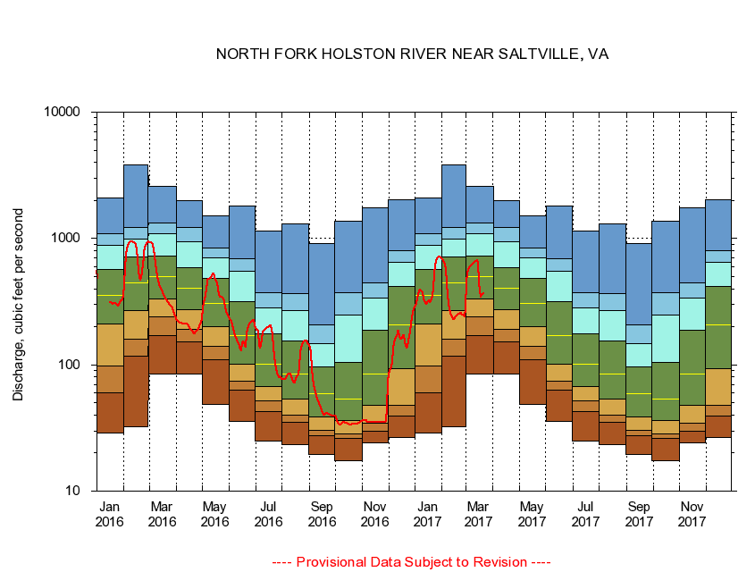
USGS - science for a changing world
Virginia DEQ

Virginia Water Science Center

 
  Duration Plot and Table of 14-Day Average Streamflow
 
03488000 NORTH FORK HOLSTON RIVER NEAR SALTVILLE, VA
LOCATION.--Latitude 36°53'48", Longitude 81°44'47", North American Datum of 1927,
                    Smyth County, VA, Hydrologic Unit 06010101.
DRAINAGE AREA.--221 square miles.
PERIOD OF RECORD.--June 1907 to December 1908 (published as "at Saltville"), October 1920 to current year. Monthly discharge only for some periods, published in WSP 1306.
DURATION STATISTIC COMPUTATION PERIOD.--All data through September 2007.
REGULATION.--No known regulation.
GAGE OPERATION.--U.S. Geological Survey, Virginia Water Science Center.

     Duration Plot with 14-Day Average Streamflow Conditions
Provisional Data Subject to Revision
03488000 plot. 
NORTH FORK HOLSTON RIVER NEAR SALTVILLE, VA
Provisional Data Subject to Revision


The current 14-day running-average value for 11/17/2008 is 28.71 cubic feet per second.

  explanation   Percentile Description Duration Plot Description 28 Day 14 Day 7 Day Daily


      Duration Table of 14-Day Average Streamflow
           
Flow values in cubic feet per second


                03488000     NORTH FORK HOLSTON RIVER NEAR SALTVILLE, VA

   Minimum daily flow
   5th percentile
 
   10th percentile
 
   25th percentile
 
 
   Median
 
 
   75th percentile


   90th percentile


   95th percentile


   Maximum daily flow
         
Years of record
January
28.9
57.7
91.5
207
348
574
877
1,090
2,090
 
88
February
32.5
112
154
268
453
730
998
1,240
3,850
 
88
March
85.1
167
236
325
489
720
1,070
1,320
2,600
 
88
April
84.7
149
187
272
400
587
952
1,260
1,990
 
88
May
48.5
106
137
191
302
490
702
846
1,520
 
88
June
35.8
62.9
74.4
102
174
332
564
702
1,800
 
88
July
24.9
42.1
51.7
70.0
102
177
279
370
1,140
 
89
August
23.2
34.9
39.7
53.6
83.2
151
249
330
1,300
 
89
September
19.4
27.4
30.2
38.2
57.1
93.5
139
209
905
 
89
October
22.6
26.9
28.9
36.4
53.5
104
243
354
1,360
 
88
November
24.1
30.0
34.9
47.4
86.6
189
346
446
1,760
 
89
December
26.6
38.9
46.7
92.0
201
406
634
790
2,020
 
89


The current 14-day running-average value for 11/17/2008 is 28.71 cubic feet per second.

---- Provisional Data Subject to Revision ----

Accessibility FOIA Privacy Policies and Notices

Take Pride in America logo USA.gov logo U.S. Department of the Interior | U.S. Geological Survey
URL: http://va.water.usgs.gov/duration_plots/htm_14/dp03488000.htm
Page Contact Information: Virginia WSC Webmaster
Page Last Modified: 9/19/2008