|
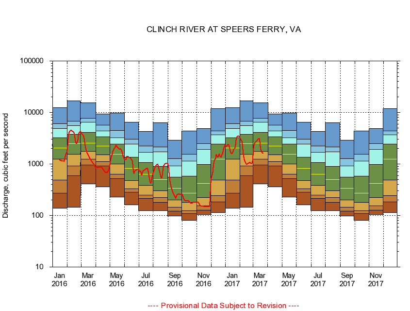
03527000
CLINCH RIVER AT SPEERS FERRY, VA
|
Minimum daily flow
|
|
|
5th percentile
|
|
|
|
10th percentile
|
|
|
|
|
25th percentile
|
|
|
|
|
|
Median
|
|
|
|
|
|
|
75th percentile
|
|
|
|
|
|
|
|
90th percentile
|
|
|
|
|
|
|
|
|
95th percentile
|
|
|
|
|
|
|
|
|
|
Maximum daily flow
|
|
|
|
|
|
|
|
|
|
|
|
Years of record
|
January
|
139
|
274
|
493
|
1,240
|
2,060
|
3,230
|
4,850
|
6,110
|
12,300
|
|
73
|
February
|
145
|
593
|
923
|
1,560
|
2,490
|
3,740
|
5,510
|
6,790
|
16,700
|
|
73
|
March
|
407
|
961
|
1,250
|
1,760
|
2,560
|
4,130
|
6,500
|
7,720
|
15,600
|
|
73
|
April
|
364
|
921
|
1,110
|
1,510
|
2,210
|
3,340
|
4,420
|
5,730
|
9,440
|
|
73
|
May
|
228
|
520
|
630
|
992
|
1,540
|
2,430
|
3,260
|
4,460
|
9,770
|
|
73
|
June
|
162
|
284
|
329
|
476
|
815
|
1,350
|
2,430
|
3,060
|
6,480
|
|
73
|
July
|
124
|
215
|
247
|
382
|
637
|
1,070
|
1,690
|
2,240
|
4,280
|
|
73
|
August
|
124
|
181
|
221
|
302
|
504
|
903
|
1,720
|
2,140
|
6,360
|
|
73
|
September
|
98.1
|
122
|
144
|
199
|
336
|
562
|
918
|
1,270
|
2,920
|
|
73
|
October
|
81.0
|
109
|
124
|
179
|
273
|
587
|
1,140
|
1,550
|
4,370
|
|
72
|
November
|
104
|
127
|
154
|
224
|
418
|
982
|
1,930
|
2,470
|
4,930
|
|
73
|
December
|
115
|
185
|
244
|
492
|
1,250
|
2,420
|
3,690
|
4,360
|
12,000
|
|
73
|
|
|
|