|
03529500
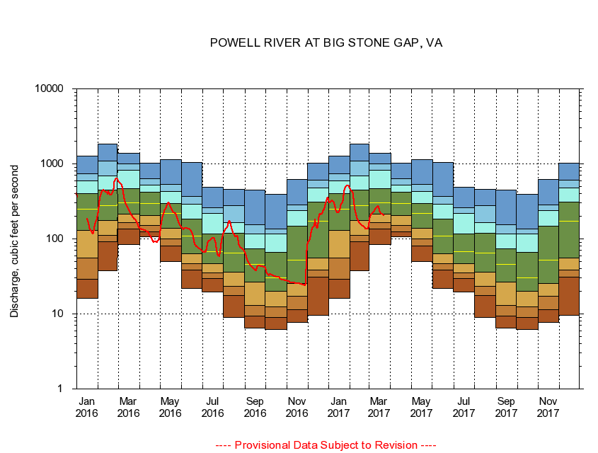
POWELL RIVER AT BIG STONE GAP, VA
|
Minimum daily flow
|
|
|
5th percentile
|
|
|
|
10th percentile
|
|
|
|
|
25th percentile
|
|
|
|
|
|
Median
|
|
|
|
|
|
|
75th percentile
|
|
|
|
|
|
|
|
90th percentile
|
|
|
|
|
|
|
|
|
95th percentile
|
|
|
|
|
|
|
|
|
|
Maximum daily flow
|
|
|
|
|
|
|
|
|
|
|
|
Years of record
|
January
|
16.1
|
29.0
|
56.1
|
130
|
249
|
400
|
598
|
736
|
1,270
|
|
32
|
February
|
37.6
|
92.6
|
112
|
175
|
279
|
447
|
691
|
1,100
|
1,830
|
|
32
|
March
|
83.7
|
137
|
165
|
212
|
306
|
466
|
816
|
1,010
|
1,400
|
|
32
|
April
|
106
|
125
|
150
|
207
|
296
|
416
|
525
|
636
|
1,030
|
|
32
|
May
|
50.1
|
81.1
|
101
|
138
|
218
|
296
|
431
|
533
|
1,150
|
|
32
|
June
|
21.9
|
38.2
|
47.1
|
63.1
|
110
|
183
|
293
|
365
|
1,040
|
|
32
|
July
|
19.5
|
29.9
|
34.9
|
46.5
|
67.8
|
116
|
220
|
258
|
485
|
|
32
|
August
|
8.90
|
17.7
|
23.4
|
36.4
|
65.4
|
118
|
165
|
276
|
461
|
|
32
|
September
|
6.43
|
9.36
|
13.1
|
26.5
|
45.9
|
73.6
|
117
|
155
|
452
|
|
32
|
October
|
6.24
|
9.01
|
12.5
|
19.9
|
30.1
|
66.5
|
116
|
137
|
395
|
|
30
|
November
|
7.71
|
11.4
|
17.1
|
25.7
|
51.9
|
147
|
241
|
282
|
622
|
|
32
|
December
|
9.49
|
30.7
|
38.2
|
55.5
|
174
|
308
|
477
|
603
|
1,030
|
|
32
|
|
|
|