|
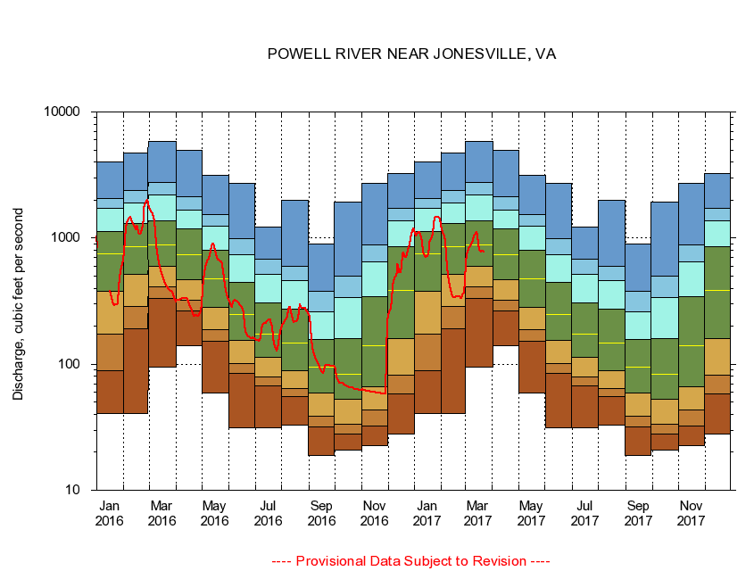
03531500
POWELL RIVER NEAR JONESVILLE, VA
|
Minimum daily flow
|
|
|
5th percentile
|
|
|
|
10th percentile
|
|
|
|
|
25th percentile
|
|
|
|
|
|
Median
|
|
|
|
|
|
|
75th percentile
|
|
|
|
|
|
|
|
90th percentile
|
|
|
|
|
|
|
|
|
95th percentile
|
|
|
|
|
|
|
|
|
|
Maximum daily flow
|
|
|
|
|
|
|
|
|
|
|
|
Years of record
|
January
|
40.6
|
89.4
|
173
|
380
|
749
|
1,130
|
1,710
|
2,070
|
4,040
|
|
84
|
February
|
40.7
|
191
|
288
|
518
|
850
|
1,310
|
1,890
|
2,390
|
4,750
|
|
84
|
March
|
95.4
|
332
|
411
|
599
|
887
|
1,380
|
2,210
|
2,760
|
5,800
|
|
84
|
April
|
140
|
266
|
323
|
465
|
732
|
1,190
|
1,670
|
2,120
|
4,980
|
|
84
|
May
|
58.9
|
153
|
189
|
284
|
472
|
799
|
1,240
|
1,540
|
3,150
|
|
84
|
June
|
31.3
|
84.0
|
101
|
154
|
248
|
442
|
741
|
988
|
2,730
|
|
84
|
July
|
31.4
|
67.4
|
79.7
|
113
|
173
|
308
|
515
|
681
|
1,230
|
|
84
|
August
|
32.8
|
55.1
|
63.6
|
88.1
|
146
|
272
|
458
|
599
|
1,990
|
|
84
|
September
|
18.8
|
31.8
|
38.5
|
59.3
|
95.4
|
156
|
259
|
378
|
897
|
|
84
|
October
|
20.7
|
27.9
|
33.4
|
52.4
|
82.8
|
160
|
336
|
500
|
1,920
|
|
83
|
November
|
22.6
|
32.3
|
43.5
|
66.6
|
139
|
342
|
648
|
877
|
2,720
|
|
84
|
December
|
28.1
|
57.9
|
81.2
|
160
|
387
|
848
|
1,360
|
1,730
|
3,260
|
|
84
|
|
|
|