|
01616500
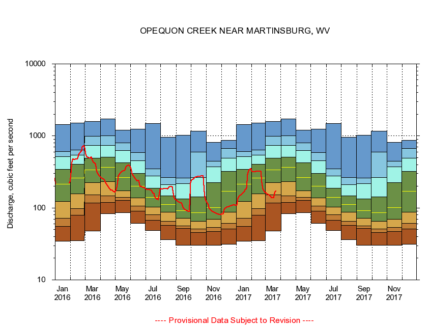
OPEQUON CREEK NEAR MARTINSBURG, WV
|
Minimum daily flow
|
|
|
5th percentile
|
|
|
|
10th percentile
|
|
|
|
|
25th percentile
|
|
|
|
|
|
Median
|
|
|
|
|
|
|
75th percentile
|
|
|
|
|
|
|
|
90th percentile
|
|
|
|
|
|
|
|
|
95th percentile
|
|
|
|
|
|
|
|
|
|
Maximum daily flow
|
|
|
|
|
|
|
|
|
|
|
|
Years of record
|
January
|
34.3
|
55.5
|
71.6
|
123
|
213
|
343
|
519
|
611
|
1,430
|
|
68
|
February
|
35.0
|
79.8
|
98.4
|
158
|
259
|
401
|
541
|
639
|
1,500
|
|
68
|
March
|
47.6
|
117
|
151
|
225
|
339
|
491
|
741
|
982
|
1,590
|
|
68
|
April
|
82.9
|
119
|
147
|
233
|
368
|
507
|
734
|
998
|
1,720
|
|
68
|
May
|
85.2
|
128
|
139
|
172
|
265
|
422
|
627
|
797
|
1,200
|
|
68
|
June
|
61.4
|
90.5
|
106
|
138
|
200
|
303
|
454
|
583
|
1,250
|
|
68
|
July
|
48.4
|
67.7
|
80.3
|
103
|
139
|
187
|
277
|
350
|
1,490
|
|
68
|
August
|
36.3
|
57.0
|
65.2
|
87.7
|
111
|
148
|
209
|
264
|
964
|
|
68
|
September
|
30.5
|
51.9
|
56.0
|
71.8
|
91.1
|
133
|
216
|
259
|
1,020
|
|
69
|
October
|
30.3
|
45.5
|
51.4
|
65.0
|
86.5
|
142
|
263
|
599
|
1,160
|
|
68
|
November
|
30.5
|
47.1
|
53.4
|
69.5
|
101
|
224
|
374
|
443
|
814
|
|
68
|
December
|
31.5
|
51.3
|
60.6
|
87.1
|
170
|
319
|
489
|
666
|
871
|
|
68
|
|
|
|