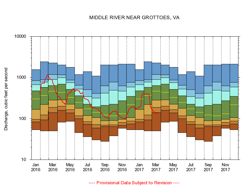
USGS - science for a changing world
Virginia DEQ

Virginia Water Science Center

 
  Duration Plot and Table of 28-Day Average Streamflow
 
01625000 MIDDLE RIVER NEAR GROTTOES, VA
LOCATION.--Latitude 38°15'42", Longitude 78°51'44", North American Datum of 1927,
                    Augusta County, VA, Hydrologic Unit 02070005.
DRAINAGE AREA.--373 square miles.
PERIOD OF RECORD.--April 1927 to current year. Records for February 1925 to September 1926, published in WSP 601 and 621, are unreliable and should not be used.
DURATION STATISTIC COMPUTATION PERIOD.--All data through September 2015.
REGULATION.--Some small diurnal fluctuation at low flow caused by mills upstream. Discharge includes discharges at treatment plants upstream, much of which is diverted from another drainage basin for industrial and municipal supply. Wastwater treatment upstream estimated input 6.4 cfs.
GAGE OPERATION.--Virginia Department of Environmental Quality - Water Division.

     Duration Plot with 28-Day Average Streamflow Conditions
Provisional Data Subject to Revision
01625000 plot. 
MIDDLE RIVER NEAR GROTTOES, VA
Provisional Data Subject to Revision


The current 28-day running-average value for 03/22/2017 is 132.29 cubic feet per second.

  explanation   Percentile Description Duration Plot Description 28 Day 14 Day 7 Day Daily


      Duration Table of 28-Day Average Streamflow
           
Flow values in cubic feet per second


                01625000     MIDDLE RIVER NEAR GROTTOES, VA

   Minimum daily flow
   5th percentile
 
   10th percentile
 
   25th percentile
 
 
   Median
 
 
   75th percentile


   90th percentile


   95th percentile


   Maximum daily flow
         
Years of record
January
53.9
83.6
95.8
167
302
474
668
845
1,550
 
88
February
50.2
93.9
122
221
365
578
781
879
2,430
 
88
March
49.9
140
188
280
466
641
896
1,190
2,280
 
88
April
82.0
160
199
289
435
688
996
1,170
2,040
 
88
May
86.5
137
165
223
328
519
750
870
1,780
 
88
June
45.2
100
118
178
248
362
524
643
1,180
 
88
July
36.2
73.0
84.9
119
173
223
345
506
1,400
 
88
August
30.3
58.8
72.3
106
142
193
318
413
1,090
 
88
September
28.1
64.3
69.0
88.4
122
210
417
624
2,010
 
88
October
38.1
63.7
70.9
89.7
117
223
487
774
2,020
 
87
November
58.5
68.6
79.9
96.6
132
273
465
630
2,130
 
88
December
53.3
73.7
86.9
107
218
346
585
761
2,130
 
88


The current 28-day running-average value for 03/22/2017 is 132.29 cubic feet per second.

---- Provisional Data Subject to Revision ----

Accessibility FOIA Privacy Policies and Notices

Take Pride in America logo USA.gov logo U.S. Department of the Interior | U.S. Geological Survey
URL: http://va.water.usgs.gov/duration_plots/htm_28/dp01625000.htm
Page Contact Information: Virginia WSC Webmaster
Page Last Modified: 6/19/2016