|
01626000
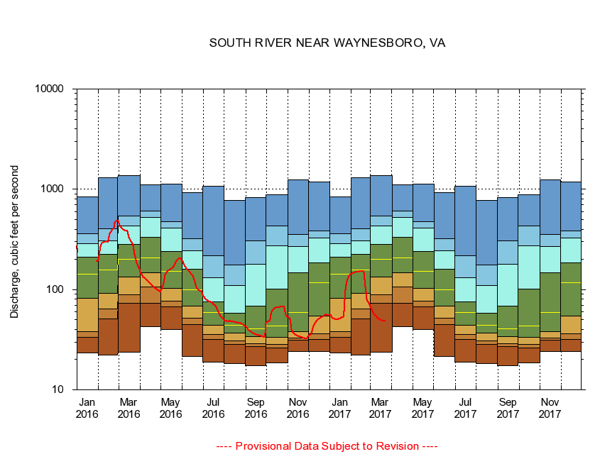
SOUTH RIVER NEAR WAYNESBORO, VA
|
Minimum daily flow
|
|
|
5th percentile
|
|
|
|
10th percentile
|
|
|
|
|
25th percentile
|
|
|
|
|
|
Median
|
|
|
|
|
|
|
75th percentile
|
|
|
|
|
|
|
|
90th percentile
|
|
|
|
|
|
|
|
|
95th percentile
|
|
|
|
|
|
|
|
|
|
Maximum daily flow
|
|
|
|
|
|
|
|
|
|
|
|
Years of record
|
January
|
23.4
|
33.4
|
38.2
|
81.8
|
142
|
211
|
285
|
360
|
834
|
|
63
|
February
|
22.1
|
50.7
|
64.4
|
92.3
|
157
|
226
|
306
|
407
|
1,310
|
|
63
|
March
|
23.7
|
72.6
|
89.3
|
133
|
201
|
284
|
430
|
545
|
1,360
|
|
63
|
April
|
42.7
|
73.3
|
106
|
146
|
207
|
330
|
523
|
606
|
1,100
|
|
63
|
May
|
39.7
|
66.8
|
76.7
|
102
|
153
|
239
|
412
|
475
|
1,120
|
|
63
|
June
|
21.5
|
45.0
|
51.7
|
68.6
|
99.8
|
160
|
245
|
324
|
924
|
|
63
|
July
|
19.0
|
31.9
|
35.5
|
44.2
|
59.0
|
75.9
|
132
|
219
|
1,070
|
|
63
|
August
|
18.2
|
28.4
|
30.9
|
37.0
|
44.0
|
57.8
|
110
|
175
|
769
|
|
63
|
September
|
17.4
|
27.2
|
28.9
|
34.2
|
40.8
|
68.6
|
179
|
306
|
826
|
|
63
|
October
|
18.5
|
26.3
|
28.4
|
33.3
|
43.6
|
101
|
275
|
430
|
882
|
|
62
|
November
|
24.2
|
31.1
|
32.6
|
38.2
|
59.5
|
146
|
270
|
353
|
1,250
|
|
63
|
December
|
24.1
|
31.7
|
36.4
|
54.5
|
117
|
184
|
327
|
387
|
1,190
|
|
63
|
|
|
|