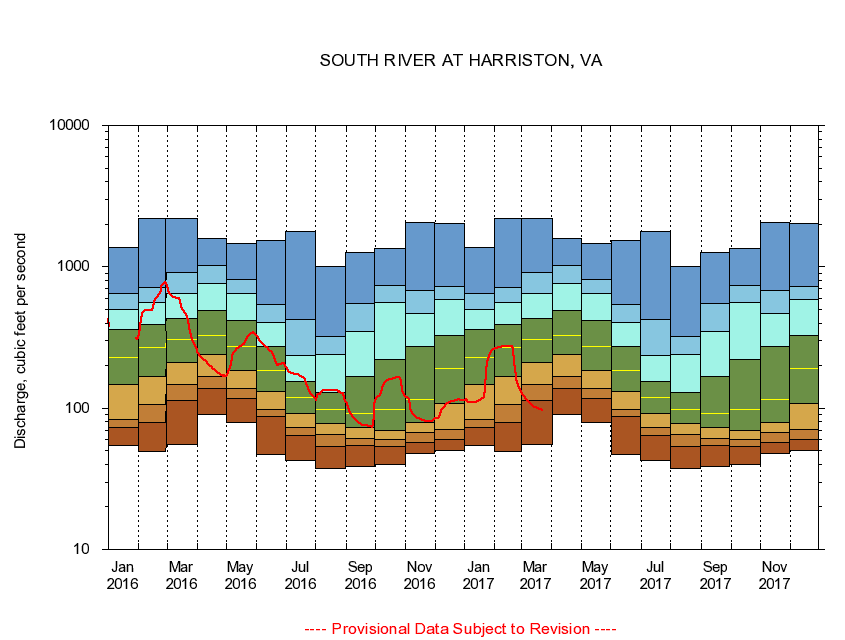
USGS - science for a changing world
Virginia DEQ

Virginia Water Science Center

 
  Duration Plot and Table of 28-Day Average Streamflow
 
01627500 SOUTH RIVER AT HARRISTON, VA
LOCATION.--Latitude 38°13'07", Longitude 78°50'13", North American Datum of 1927,
                    Augusta County, VA, Hydrologic Unit 02070005.
DRAINAGE AREA.--212 square miles.
PERIOD OF RECORD.--February 1925 to September 1951, October 1968 to current year.
DURATION STATISTIC COMPUTATION PERIOD.--All data through September 2015.
REGULATION.--Historically a mill operated 0.4 miles upstream of gage. Wastwater treatment upstream estimated input 12.6 cfs.
GAGE OPERATION.--Virginia Department of Environmental Quality - Water Division.

     Duration Plot with 28-Day Average Streamflow Conditions
Provisional Data Subject to Revision
01627500 plot. 
SOUTH RIVER AT HARRISTON, VA
Provisional Data Subject to Revision


The current 28-day running-average value for 03/22/2017 is 96.89 cubic feet per second.

  explanation   Percentile Description Duration Plot Description 28 Day 14 Day 7 Day Daily


      Duration Table of 28-Day Average Streamflow
           
Flow values in cubic feet per second


                01627500     SOUTH RIVER AT HARRISTON, VA

   Minimum daily flow
   5th percentile
 
   10th percentile
 
   25th percentile
 
 
   Median
 
 
   75th percentile


   90th percentile


   95th percentile


   Maximum daily flow
         
Years of record
January
54.5
72.4
83.2
146
227
361
503
644
1,360
 
73
February
49.0
79.4
107
167
267
394
556
712
2,200
 
73
March
55.0
113
147
209
308
433
651
917
2,200
 
73
April
90.5
138
167
239
325
491
764
1,030
1,580
 
74
May
79.8
118
137
184
272
416
650
808
1,470
 
74
June
46.7
86.8
98.6
131
184
275
401
540
1,540
 
74
July
42.5
64.3
73.1
92.3
119
155
236
423
1,790
 
74
August
37.5
53.9
65.0
77.5
98.1
129
239
323
1,010
 
74
September
38.5
54.7
60.6
72.8
91.4
167
348
554
1,260
 
74
October
39.7
53.4
60.3
69.7
97.4
222
562
738
1,350
 
72
November
47.5
57.4
67.2
78.8
115
274
464
683
2,050
 
73
December
50.4
60.3
70.7
108
192
329
586
721
2,010
 
73


The current 28-day running-average value for 03/22/2017 is 96.89 cubic feet per second.

---- Provisional Data Subject to Revision ----

Accessibility FOIA Privacy Policies and Notices

Take Pride in America logo USA.gov logo U.S. Department of the Interior | U.S. Geological Survey
URL: http://va.water.usgs.gov/duration_plots/htm_28/dp01627500.htm
Page Contact Information: Virginia WSC Webmaster
Page Last Modified: 6/19/2016