|
01633000
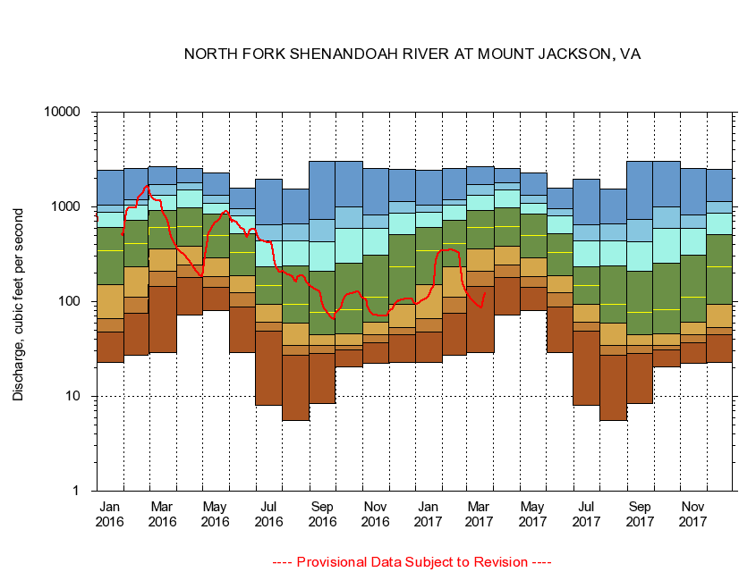
NORTH FORK SHENANDOAH RIVER AT MOUNT JACKSON, VA
|
Minimum daily flow
|
|
|
5th percentile
|
|
|
|
10th percentile
|
|
|
|
|
25th percentile
|
|
|
|
|
|
Median
|
|
|
|
|
|
|
75th percentile
|
|
|
|
|
|
|
|
90th percentile
|
|
|
|
|
|
|
|
|
95th percentile
|
|
|
|
|
|
|
|
|
|
Maximum daily flow
|
|
|
|
|
|
|
|
|
|
|
|
Years of record
|
January
|
22.6
|
48.2
|
66.9
|
151
|
342
|
603
|
885
|
1,050
|
2,460
|
|
72
|
February
|
27.0
|
75.2
|
112
|
233
|
413
|
720
|
1,040
|
1,200
|
2,540
|
|
72
|
March
|
28.7
|
146
|
211
|
363
|
608
|
922
|
1,340
|
1,720
|
2,630
|
|
72
|
April
|
72.6
|
179
|
243
|
383
|
622
|
985
|
1,510
|
1,780
|
2,570
|
|
72
|
May
|
81.3
|
141
|
185
|
287
|
502
|
832
|
1,090
|
1,330
|
2,270
|
|
72
|
June
|
28.8
|
86.9
|
124
|
186
|
330
|
523
|
803
|
957
|
1,570
|
|
72
|
July
|
8.06
|
48.4
|
61.3
|
93.3
|
149
|
235
|
435
|
650
|
1,970
|
|
72
|
August
|
5.54
|
27.2
|
34.8
|
58.9
|
94.2
|
237
|
438
|
660
|
1,550
|
|
72
|
September
|
8.43
|
28.5
|
34.8
|
45.1
|
77.2
|
209
|
431
|
736
|
3,010
|
|
72
|
October
|
20.4
|
30.7
|
34.5
|
45.8
|
82.4
|
253
|
591
|
1,010
|
3,000
|
|
71
|
November
|
22.2
|
36.5
|
44.8
|
61.2
|
111
|
307
|
599
|
823
|
2,520
|
|
72
|
December
|
22.6
|
44.3
|
52.9
|
94.4
|
231
|
513
|
859
|
1,130
|
2,480
|
|
72
|
|
|
|