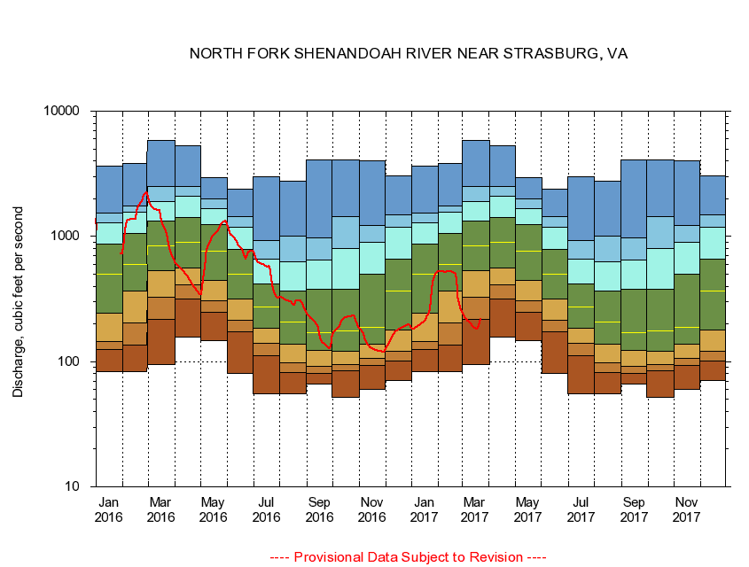
USGS - science for a changing world
Virginia DEQ

Virginia Water Science Center

 
  Duration Plot and Table of 28-Day Average Streamflow
 
01634000 NORTH FORK SHENANDOAH RIVER NEAR STRASBURG, VA
LOCATION.--Latitude 38°58'36", Longitude 78°20'11", North American Datum of 1927,
                    Warren County, VA, Hydrologic Unit 02070006.
DRAINAGE AREA.--770 square miles.
PERIOD OF RECORD.--April 1925 to current year.
DURATION STATISTIC COMPUTATION PERIOD.--All data through September 2015.
REGULATION.--Large diurnal fluctuation at low and medium flow caused by a hydroelectric plant upstream, and from other unknown sources.
GAGE OPERATION.--U.S. Geological Survey, Virginia Water Science Center.

     Duration Plot with 28-Day Average Streamflow Conditions
Provisional Data Subject to Revision
01634000 plot. 
NORTH FORK SHENANDOAH RIVER NEAR STRASBURG, VA
Provisional Data Subject to Revision


The current 28-day running-average value for 03/22/2017 is 217 cubic feet per second.

  explanation   Percentile Description Duration Plot Description 28 Day 14 Day 7 Day Daily


      Duration Table of 28-Day Average Streamflow
           
Flow values in cubic feet per second


                01634000     NORTH FORK SHENANDOAH RIVER NEAR STRASBURG, VA

   Minimum daily flow
   5th percentile
 
   10th percentile
 
   25th percentile
 
 
   Median
 
 
   75th percentile


   90th percentile


   95th percentile


   Maximum daily flow
         
Years of record
January
83.0
124
145
243
497
865
1,280
1,530
3,670
 
90
February
83.6
135
203
368
601
1,060
1,560
1,760
3,850
 
90
March
94.5
216
326
529
845
1,320
1,890
2,510
5,840
 
90
April
156
314
411
561
896
1,420
2,080
2,490
5,300
 
90
May
148
248
308
446
767
1,240
1,660
1,990
2,970
 
91
June
80.8
173
214
316
503
784
1,180
1,430
2,390
 
91
July
55.1
112
140
185
275
419
654
922
2,980
 
91
August
55.1
81.8
97.2
138
206
369
630
1,010
2,770
 
91
September
66.6
80.2
91.7
123
169
380
646
977
4,080
 
91
October
52.0
84.4
94.8
121
175
381
798
1,440
4,110
 
90
November
60.4
92.5
106
137
189
495
904
1,220
3,990
 
90
December
70.2
101
121
178
364
662
1,180
1,490
3,020
 
90


The current 28-day running-average value for 03/22/2017 is 217 cubic feet per second.

---- Provisional Data Subject to Revision ----

Accessibility FOIA Privacy Policies and Notices

Take Pride in America logo USA.gov logo U.S. Department of the Interior | U.S. Geological Survey
URL: http://va.water.usgs.gov/duration_plots/htm_28/dp01634000.htm
Page Contact Information: Virginia WSC Webmaster
Page Last Modified: 6/19/2016