|
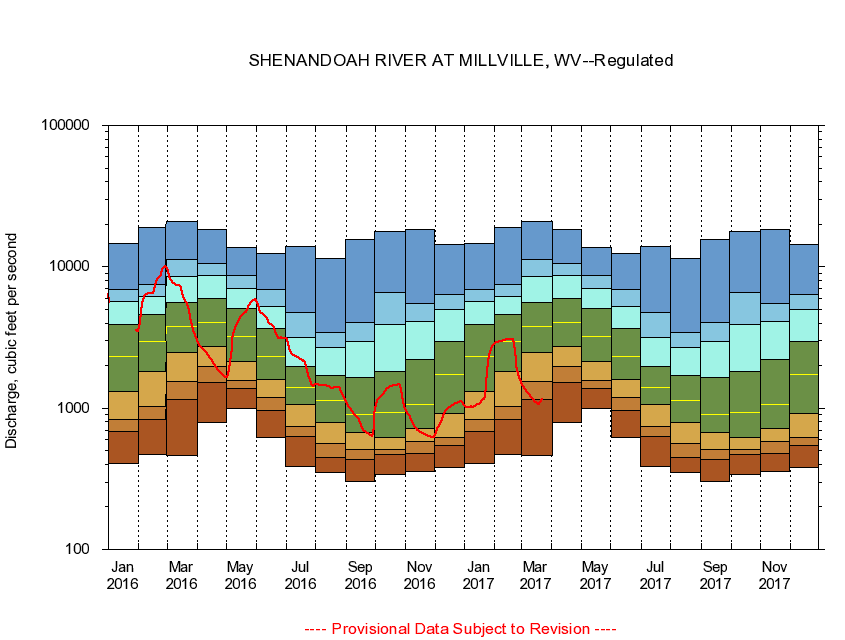
01636500
SHENANDOAH RIVER AT MILLVILLE, WV
|
Minimum daily flow
|
|
|
5th percentile
|
|
|
|
10th percentile
|
|
|
|
|
25th percentile
|
|
|
|
|
|
Median
|
|
|
|
|
|
|
75th percentile
|
|
|
|
|
|
|
|
90th percentile
|
|
|
|
|
|
|
|
|
95th percentile
|
|
|
|
|
|
|
|
|
|
Maximum daily flow
|
|
|
|
|
|
|
|
|
|
|
|
Years of record
|
January
|
408
|
684
|
838
|
1,320
|
2,310
|
3,920
|
5,650
|
6,900
|
14,600
|
|
101
|
February
|
471
|
833
|
1,030
|
1,820
|
2,950
|
4,570
|
6,200
|
7,440
|
19,100
|
|
101
|
March
|
463
|
1,160
|
1,550
|
2,460
|
3,760
|
5,620
|
8,500
|
11,200
|
21,000
|
|
101
|
April
|
795
|
1,510
|
1,970
|
2,720
|
4,020
|
5,960
|
8,650
|
10,600
|
18,400
|
|
101
|
May
|
988
|
1,380
|
1,560
|
2,150
|
3,200
|
5,100
|
7,070
|
8,660
|
13,600
|
|
101
|
June
|
617
|
955
|
1,190
|
1,600
|
2,320
|
3,640
|
5,280
|
6,910
|
12,500
|
|
101
|
July
|
389
|
635
|
744
|
1,060
|
1,400
|
1,980
|
3,150
|
4,720
|
14,000
|
|
101
|
August
|
351
|
449
|
560
|
786
|
1,130
|
1,700
|
2,680
|
3,410
|
11,400
|
|
101
|
September
|
305
|
435
|
507
|
669
|
908
|
1,660
|
2,980
|
4,050
|
15,700
|
|
102
|
October
|
342
|
473
|
511
|
620
|
931
|
1,810
|
3,920
|
6,590
|
17,800
|
|
101
|
November
|
354
|
478
|
581
|
715
|
1,070
|
2,220
|
4,100
|
5,460
|
18,500
|
|
101
|
December
|
382
|
543
|
623
|
915
|
1,740
|
2,950
|
4,980
|
6,400
|
14,400
|
|
101
|
|
|
|