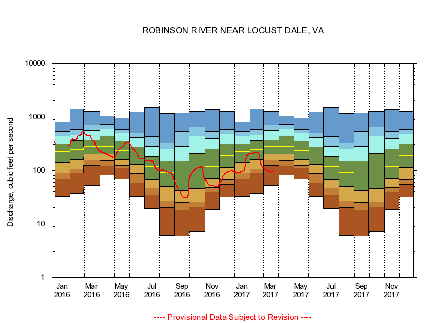
USGS - science for a changing world
Virginia DEQ

Virginia Water Science Center

 
  Duration Plot and Table of 28-Day Average Streamflow
 
01666500 ROBINSON RIVER NEAR LOCUST DALE, VA
LOCATION.--Latitude 38°19'30", Longitude 78°05'45", North American Datum of 1927,
                    Madison County, VA, Hydrologic Unit 02080103.
DRAINAGE AREA.--179 square miles.
PERIOD OF RECORD.--July 1943 to current year. Prior to October 1965, published as Robertson River near Locust Dale.
DURATION STATISTIC COMPUTATION PERIOD.--All data through September 2007.
REGULATION.--Low flow regulated by powerplant about 11 miles above station and at mill about 14 miles above station in prior years.
GAGE OPERATION.--Virginia Department of Environmental Quality - Water Division.

     Duration Plot with 28-Day Average Streamflow Conditions
Provisional Data Subject to Revision
01666500 plot. 
ROBINSON RIVER NEAR LOCUST DALE, VA
Provisional Data Subject to Revision


The current 28-day running-average value for 10/14/2008 is 52.71 cubic feet per second.

  explanation   Percentile Description Duration Plot Description 28 Day 14 Day 7 Day Daily


      Duration Table of 28-Day Average Streamflow
           
Flow values in cubic feet per second


                01666500     ROBINSON RIVER NEAR LOCUST DALE, VA

   Minimum daily flow
   5th percentile
 
   10th percentile
 
   25th percentile
 
 
   Median
 
 
   75th percentile


   90th percentile


   95th percentile


   Maximum daily flow
         
Years of record
January
32.2
67.8
96.8
144
226
305
437
533
813
 
64
February
37.1
87.9
110
165
247
358
457
598
1,430
 
64
March
51.8
133
159
204
277
364
558
705
1,270
 
64
April
82.5
120
151
203
277
446
613
724
1,040
 
64
May
69.5
108
121
156
228
332
474
554
956
 
64
June
32.2
57.2
84.2
127
186
262
400
492
1,230
 
64
July
19.0
32.8
44.4
66.6
117
178
285
439
1,480
 
64
August
6.12
19.0
25.7
49.4
95.4
156
255
336
1,170
 
64
September
5.94
17.1
24.4
42.3
76.9
158
321
571
1,190
 
65
October
7.15
21.6
25.7
45.4
90.2
214
481
679
1,260
 
64
November
18.4
39.2
48.0
69.7
122
266
408
542
1,390
 
64
December
31.9
57.9
68.5
116
186
304
494
593
1,280
 
64


The current 28-day running-average value for 10/14/2008 is 52.71 cubic feet per second.

---- Provisional Data Subject to Revision ----

Accessibility FOIA Privacy Policies and Notices

Take Pride in America logo USA.gov logo U.S. Department of the Interior | U.S. Geological Survey
URL: http://va.water.usgs.gov/duration_plots/htm_28/dp01666500.htm
Page Contact Information: Virginia WSC Webmaster
Page Last Modified: 9/19/2008