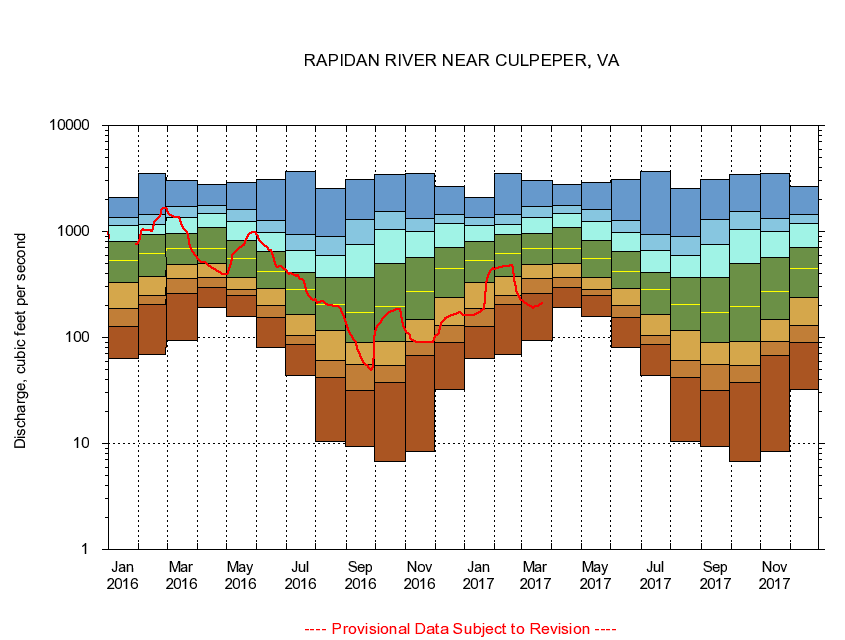
USGS - science for a changing world
Virginia DEQ

Virginia Water Science Center

 
  Duration Plot and Table of 28-Day Average Streamflow
 
01667500 RAPIDAN RIVER NEAR CULPEPER, VA
LOCATION.--Latitude 38°21'01", Longitude 77°58'31", North American Datum of 1927,
                    Culpeper County, VA, Hydrologic Unit 02080103.
DRAINAGE AREA.--468 square miles.
PERIOD OF RECORD.--October 1930 to current year. Monthly discharge only for some periods, published in WSP 1302.
DURATION STATISTIC COMPUTATION PERIOD.--All data through September 2015.
REGULATION.--Low-water flow regulated by operation of mill prior to 1977, since 1986 by a powerplant. Some diversion during summer months for irrigation.
GAGE OPERATION.--Virginia Department of Environmental Quality - Water Division.

     Duration Plot with 28-Day Average Streamflow Conditions
Provisional Data Subject to Revision
01667500 plot. 
RAPIDAN RIVER NEAR CULPEPER, VA
Provisional Data Subject to Revision


The current 28-day running-average value for 03/22/2017 is 208.64 cubic feet per second.

  explanation   Percentile Description Duration Plot Description 28 Day 14 Day 7 Day Daily


      Duration Table of 28-Day Average Streamflow
           
Flow values in cubic feet per second


                01667500     RAPIDAN RIVER NEAR CULPEPER, VA

   Minimum daily flow
   5th percentile
 
   10th percentile
 
   25th percentile
 
 
   Median
 
 
   75th percentile


   90th percentile


   95th percentile


   Maximum daily flow
         
Years of record
January
63.6
126
187
332
536
806
1,130
1,360
2,090
 
85
February
68.8
203
247
376
614
928
1,170
1,450
3,530
 
85
March
92.7
259
360
490
687
955
1,370
1,720
3,060
 
85
April
190
297
369
502
690
1,090
1,470
1,770
2,780
 
85
May
159
250
285
370
552
825
1,230
1,630
2,880
 
85
June
80.7
154
199
292
422
652
974
1,260
3,090
 
85
July
43.7
85.1
105
166
283
411
669
937
3,720
 
85
August
10.5
42.0
60.7
117
207
368
592
894
2,560
 
85
September
9.37
31.7
55.4
90.4
172
367
746
1,310
3,100
 
85
October
6.82
37.9
54.8
92.5
198
496
1,050
1,550
3,440
 
84
November
8.39
67.3
90.8
147
271
570
1,000
1,320
3,510
 
85
December
32.1
90.4
130
237
450
701
1,180
1,460
2,670
 
85


The current 28-day running-average value for 03/22/2017 is 208.64 cubic feet per second.

---- Provisional Data Subject to Revision ----

Accessibility FOIA Privacy Policies and Notices

Take Pride in America logo USA.gov logo U.S. Department of the Interior | U.S. Geological Survey
URL: http://va.water.usgs.gov/duration_plots/htm_28/dp01667500.htm
Page Contact Information: Virginia WSC Webmaster
Page Last Modified: 6/19/2016