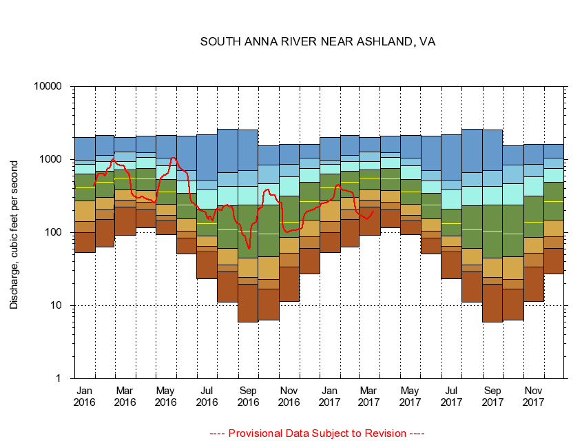
USGS - science for a changing world
Virginia DEQ

Virginia Water Science Center

 
  Duration Plot and Table of 28-Day Average Streamflow
 
01672500 SOUTH ANNA RIVER NEAR ASHLAND, VA
LOCATION.--Latitude 37°47'48", Longitude 77°32'57", North American Datum of 1927,
                    Hanover County, VA, Hydrologic Unit 02080106.
DRAINAGE AREA.--395 square miles.
PERIOD OF RECORD.--October 1930 to September 1997, June 2003 to current year.
DURATION STATISTIC COMPUTATION PERIOD.--All data through September 2015.
REGULATION.--Small diurnal fluctuation at low flow in some years caused by mills upstream from station. Since 1966, diversion upstream averaged less than 0.6 cfs. Capacity of the diversion is about 1.5 cfs.
GAGE OPERATION.--U.S. Geological Survey, Virginia Water Science Center.

     Duration Plot with 28-Day Average Streamflow Conditions
Provisional Data Subject to Revision
01672500 plot. 
SOUTH ANNA RIVER NEAR ASHLAND, VA
Provisional Data Subject to Revision


The current 28-day running-average value for 03/22/2017 is 190.18 cubic feet per second.

  explanation   Percentile Description Duration Plot Description 28 Day 14 Day 7 Day Daily


      Duration Table of 28-Day Average Streamflow
           
Flow values in cubic feet per second


                01672500     SOUTH ANNA RIVER NEAR ASHLAND, VA

   Minimum daily flow
   5th percentile
 
   10th percentile
 
   25th percentile
 
 
   Median
 
 
   75th percentile


   90th percentile


   95th percentile


   Maximum daily flow
         
Years of record
January
53.8
101
141
269
410
636
850
974
2,010
 
79
February
63.6
151
203
300
490
691
927
1,130
2,150
 
79
March
91.2
224
277
386
553
719
930
1,280
2,000
 
79
April
117
205
260
376
547
753
1,070
1,250
2,090
 
79
May
93.0
146
174
245
361
534
828
1,050
2,140
 
79
June
51.1
84.8
105
154
236
346
513
705
2,110
 
79
July
23.2
54.5
65.0
89.2
134
211
382
517
2,200
 
79
August
11.2
28.9
36.1
61.3
110
231
433
658
2,610
 
80
September
5.96
19.6
24.5
44.9
104
239
430
706
2,520
 
80
October
6.29
16.9
22.9
46.9
95.2
239
466
843
1,560
 
78
November
11.3
33.8
51.9
86.0
138
316
586
855
1,610
 
79
December
26.9
60.2
87.5
148
267
490
757
1,040
1,610
 
79


The current 28-day running-average value for 03/22/2017 is 190.18 cubic feet per second.

---- Provisional Data Subject to Revision ----

Accessibility FOIA Privacy Policies and Notices

Take Pride in America logo USA.gov logo U.S. Department of the Interior | U.S. Geological Survey
URL: http://va.water.usgs.gov/duration_plots/htm_28/dp01672500.htm
Page Contact Information: Virginia WSC Webmaster
Page Last Modified: 6/19/2016