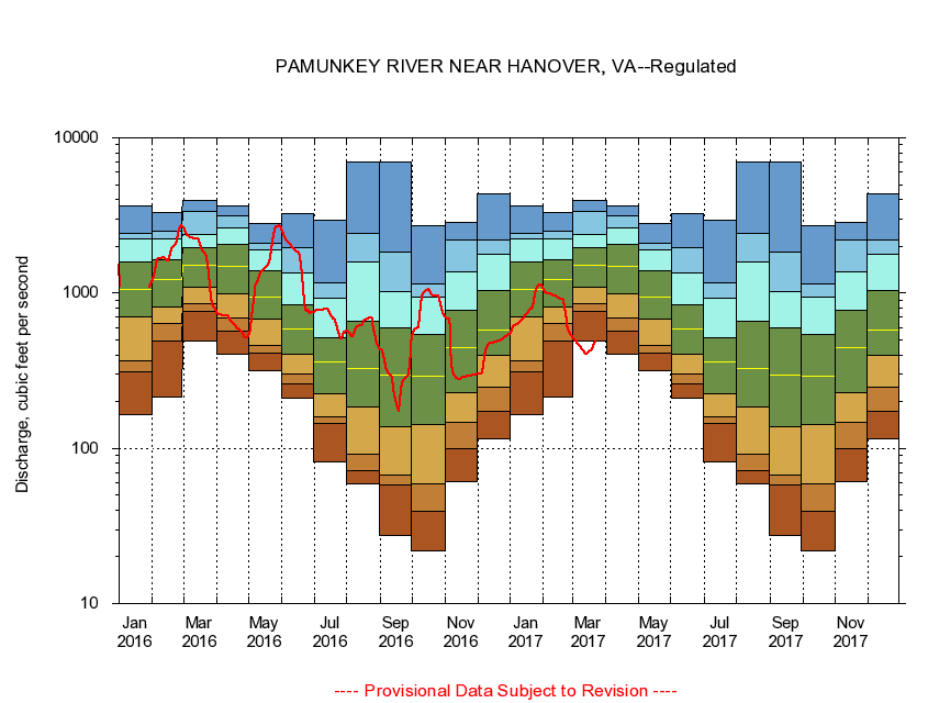
USGS - science for a changing world
Virginia DEQ

Virginia Water Science Center

 
  Duration Plot and Table of 28-Day Average Streamflow
 
01673000 PAMUNKEY RIVER NEAR HANOVER, VA
LOCATION.--Latitude 37°46'03", Longitude 77°19'57", North American Datum of 1927,
                    Hanover County, VA, Hydrologic Unit 02080106.
DRAINAGE AREA.--1,078 square miles.
PERIOD OF RECORD.--October 1941 to current year. Monthly discharge only for some periods, published in WSP 1302.
DURATION STATISTIC COMPUTATION PERIOD.--October 1941 to January 1972.
REGULATION.--Slight regulation from small mill dams upstream and by Lake Anna Power Station on North River since January 1972. Some diversion during summer months for irrigation.
GAGE OPERATION.--U.S. Geological Survey, Virginia Water Science Center.

     Duration Plot with 28-Day Average Streamflow Conditions
Provisional Data Subject to Revision
01673000 plot. 
PAMUNKEY RIVER NEAR HANOVER, VA
Provisional Data Subject to Revision


The current 28-day running-average value for 03/22/2017 is 483.36 cubic feet per second.

  explanation   Percentile Description Duration Plot Description 28 Day 14 Day 7 Day Daily


      Duration Table of 28-Day Average Streamflow
           
Flow values in cubic feet per second


                01673000     PAMUNKEY RIVER NEAR HANOVER, VA

   Minimum daily flow
   5th percentile
 
   10th percentile
 
   25th percentile
 
 
   Median
 
 
   75th percentile


   90th percentile


   95th percentile


   Maximum daily flow
         
Years of record
January
166
310
368
707
1,060
1,580
2,230
2,440
3,630
 
30
February
213
487
641
807
1,220
1,650
2,220
2,500
3,290
 
30
March
490
766
855
1,090
1,520
1,960
2,400
3,350
3,960
 
30
April
407
564
689
987
1,490
2,060
2,620
3,120
3,650
 
30
May
315
410
463
676
948
1,400
1,910
2,080
2,800
 
30
June
209
262
300
407
583
836
1,340
1,960
3,270
 
30
July
82.2
144
160
223
359
514
921
1,170
2,970
 
30
August
59.3
71.4
92.0
185
326
663
1,590
2,440
7,000
 
30
September
27.6
57.7
67.1
138
294
596
1,030
1,850
6,950
 
30
October
21.9
39.6
58.9
143
292
540
947
1,150
2,710
 
30
November
61.2
100
147
228
443
776
1,380
2,210
2,840
 
31
December
116
174
248
400
581
1,040
1,790
2,190
4,330
 
31


The current 28-day running-average value for 03/22/2017 is 483.36 cubic feet per second.

---- Provisional Data Subject to Revision ----

Accessibility FOIA Privacy Policies and Notices

Take Pride in America logo USA.gov logo U.S. Department of the Interior | U.S. Geological Survey
URL: http://va.water.usgs.gov/duration_plots/htm_28/dp01673000.htm
Page Contact Information: Virginia WSC Webmaster
Page Last Modified: 6/19/2016