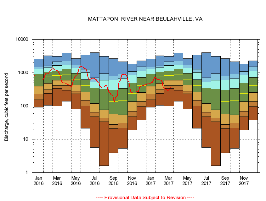
USGS - science for a changing world
Virginia DEQ

Virginia Water Science Center

 
  Duration Plot and Table of 28-Day Average Streamflow
 
01674500 MATTAPONI RIVER NEAR BEULAHVILLE, VA
LOCATION.--Latitude 37°53'16", Longitude 77°09'48", North American Datum of 1927,
                    King William County, VA, Hydrologic Unit 02080105.
DRAINAGE AREA.--602 square miles.
PERIOD OF RECORD.--September 1941 to September 1987, October 1989 to current year.
DURATION STATISTIC COMPUTATION PERIOD.--All data through September 2007.
REGULATION.--Some regulation in the past, during low flows, caused by mill on Po River.
GAGE OPERATION.--U.S. Geological Survey, Virginia Water Science Center.

     Duration Plot with 28-Day Average Streamflow Conditions
Provisional Data Subject to Revision
01674500 plot. 
MATTAPONI RIVER NEAR BEULAHVILLE, VA
Provisional Data Subject to Revision


The current 28-day running-average value for 08/28/2008 is 31.94 cubic feet per second.

  explanation   Percentile Description Duration Plot Description 28 Day 14 Day 7 Day Daily


      Duration Table of 28-Day Average Streamflow
           
Flow values in cubic feet per second


                01674500     MATTAPONI RIVER NEAR BEULAHVILLE, VA

   Minimum daily flow
   5th percentile
 
   10th percentile
 
   25th percentile
 
 
   Median
 
 
   75th percentile


   90th percentile


   95th percentile


   Maximum daily flow
         
Years of record
January
92.4
148
234
428
660
924
1,300
1,460
2,600
 
64
February
104
229
344
535
774
1,080
1,470
1,640
3,230
 
64
March
101
352
453
620
851
1,180
1,750
2,200
3,070
 
64
April
140
285
397
626
938
1,350
1,810
2,290
3,930
 
64
May
81.8
225
265
407
644
968
1,390
1,710
2,640
 
64
June
21.4
91.5
137
249
394
623
1,060
1,270
3,340
 
64
July
5.64
48.5
66.5
121
218
342
535
760
4,050
 
64
August
1.61
30.2
47.3
83.2
176
346
656
982
3,080
 
64
September
3.92
20.1
27.0
57.0
148
329
616
802
2,640
 
64
October
5.30
24.0
30.9
57.1
166
362
677
940
2,120
 
63
November
19.2
45.3
66.0
148
276
499
902
1,140
1,820
 
64
December
37.3
93.7
147
282
425
705
1,130
1,470
2,270
 
64


The current 28-day running-average value for 08/28/2008 is 31.94 cubic feet per second.

---- Provisional Data Subject to Revision ----

Accessibility FOIA Privacy Policies and Notices

Take Pride in America logo USA.gov logo U.S. Department of the Interior | U.S. Geological Survey
URL: http://va.water.usgs.gov/duration_plots/htm_28/dp01674500.htm
Page Contact Information: Virginia WSC Webmaster
Page Last Modified: 8/6/2008