|
02029000
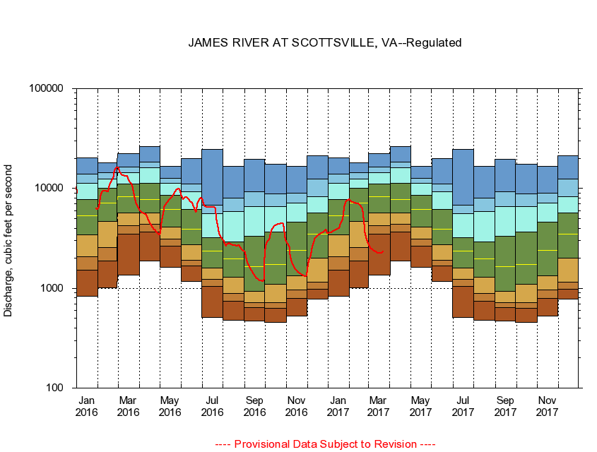
JAMES RIVER AT SCOTTSVILLE, VA
|
Minimum daily flow
|
|
|
5th percentile
|
|
|
|
10th percentile
|
|
|
|
|
25th percentile
|
|
|
|
|
|
Median
|
|
|
|
|
|
|
75th percentile
|
|
|
|
|
|
|
|
90th percentile
|
|
|
|
|
|
|
|
|
95th percentile
|
|
|
|
|
|
|
|
|
|
Maximum daily flow
|
|
|
|
|
|
|
|
|
|
|
|
Years of record
|
January
|
831
|
1,520
|
2,070
|
3,410
|
5,350
|
7,800
|
11,200
|
13,900
|
20,400
|
|
55
|
February
|
1,010
|
1,870
|
2,550
|
4,710
|
7,090
|
10,100
|
12,500
|
14,400
|
18,000
|
|
55
|
March
|
1,360
|
3,480
|
4,250
|
5,730
|
8,290
|
11,000
|
14,300
|
16,300
|
22,500
|
|
55
|
April
|
1,890
|
3,660
|
4,380
|
5,700
|
7,810
|
11,200
|
16,000
|
18,500
|
26,100
|
|
55
|
May
|
1,630
|
2,650
|
3,090
|
4,100
|
6,150
|
8,550
|
11,200
|
12,700
|
16,600
|
|
55
|
June
|
1,180
|
1,680
|
1,910
|
2,710
|
3,910
|
6,170
|
9,230
|
11,100
|
19,900
|
|
55
|
July
|
513
|
1,040
|
1,230
|
1,590
|
2,350
|
3,230
|
5,590
|
6,780
|
24,800
|
|
55
|
August
|
481
|
745
|
886
|
1,290
|
1,980
|
2,920
|
5,890
|
8,060
|
16,700
|
|
55
|
September
|
470
|
644
|
722
|
930
|
1,660
|
3,320
|
6,540
|
9,240
|
19,500
|
|
55
|
October
|
456
|
631
|
722
|
1,100
|
1,740
|
3,680
|
6,550
|
8,800
|
17,500
|
|
55
|
November
|
524
|
798
|
966
|
1,340
|
2,400
|
4,600
|
7,120
|
8,920
|
16,600
|
|
56
|
December
|
779
|
980
|
1,150
|
2,010
|
3,510
|
5,710
|
8,230
|
12,400
|
21,400
|
|
55
|
|
|
|