|
02035000
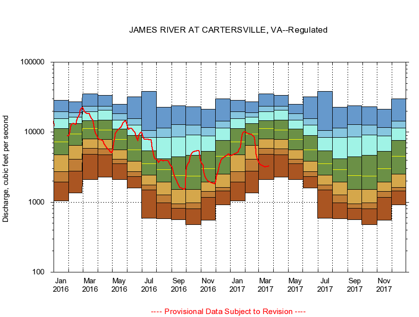
JAMES RIVER AT CARTERSVILLE, VA
|
Minimum daily flow
|
|
|
5th percentile
|
|
|
|
10th percentile
|
|
|
|
|
25th percentile
|
|
|
|
|
|
Median
|
|
|
|
|
|
|
75th percentile
|
|
|
|
|
|
|
|
90th percentile
|
|
|
|
|
|
|
|
|
95th percentile
|
|
|
|
|
|
|
|
|
|
Maximum daily flow
|
|
|
|
|
|
|
|
|
|
|
|
Years of record
|
January
|
1,040
|
1,940
|
2,740
|
4,760
|
7,280
|
11,200
|
15,500
|
19,600
|
28,600
|
|
83
|
February
|
1,350
|
2,760
|
4,130
|
6,430
|
9,380
|
13,200
|
16,300
|
19,000
|
27,000
|
|
84
|
March
|
2,120
|
4,850
|
5,900
|
7,980
|
11,300
|
14,700
|
19,600
|
23,500
|
35,400
|
|
84
|
April
|
2,290
|
4,760
|
5,810
|
7,830
|
10,800
|
14,800
|
20,600
|
23,500
|
33,500
|
|
84
|
May
|
2,110
|
3,530
|
4,100
|
5,570
|
7,930
|
11,000
|
14,900
|
18,300
|
25,100
|
|
84
|
June
|
1,590
|
2,310
|
2,720
|
3,860
|
5,590
|
8,920
|
12,600
|
15,600
|
31,900
|
|
83
|
July
|
588
|
1,500
|
1,760
|
2,420
|
3,550
|
5,380
|
8,400
|
10,600
|
38,100
|
|
83
|
August
|
582
|
973
|
1,260
|
1,940
|
2,930
|
4,200
|
8,410
|
11,500
|
22,600
|
|
83
|
September
|
560
|
812
|
953
|
1,510
|
2,400
|
4,450
|
8,530
|
12,800
|
23,900
|
|
83
|
October
|
480
|
803
|
986
|
1,530
|
2,340
|
4,650
|
9,060
|
12,700
|
23,100
|
|
83
|
November
|
555
|
1,170
|
1,430
|
1,940
|
3,000
|
5,300
|
8,850
|
11,600
|
21,300
|
|
83
|
December
|
919
|
1,440
|
1,620
|
2,520
|
4,550
|
7,620
|
11,500
|
14,400
|
29,800
|
|
83
|
|
|
|