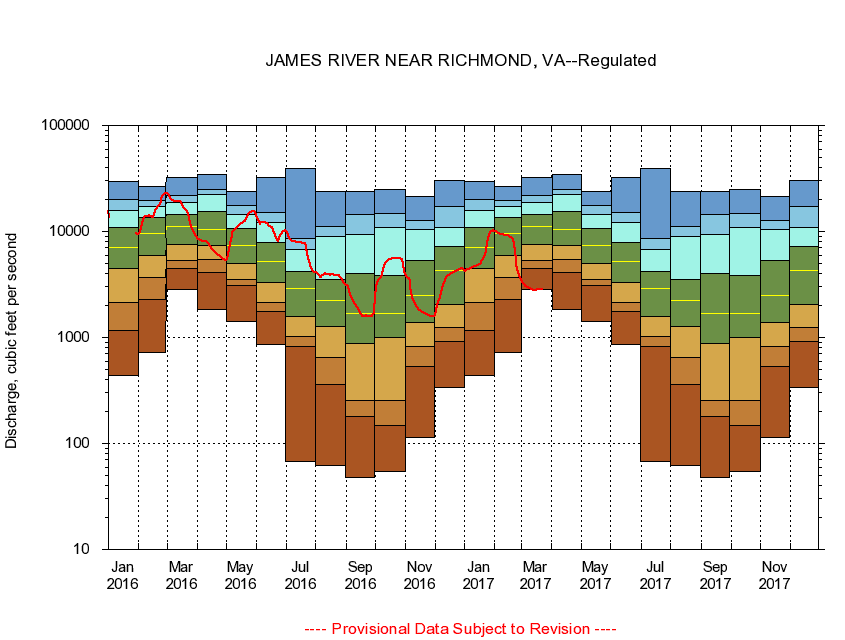
USGS - science for a changing world
Virginia DEQ

Virginia Water Science Center

 
  Duration Plot and Table of 28-Day Average Streamflow
 
02037500 JAMES RIVER NEAR RICHMOND, VA
LOCATION.--Latitude 37°33'47", Longitude 77°32'50", North American Datum of 1927,
                    Henrico County, VA, Hydrologic Unit 02080205.
DRAINAGE AREA.--6,753 square miles.
PERIOD OF RECORD.--October 1934 to current year. Gage-height records collected in vicinity of Mayo's Bridge, at mile 109.5, 1876-1956, and at mile 108.7 since 1957, are contained in reports of the National Weather Service.
DURATION STATISTIC COMPUTATION PERIOD.--October 1934 to June 1982.
REGULATION.--Regulation from upstream powerplants. Diversion through the Kanawha Canal. Flow augmented by summertime releases since June 1982.
GAGE OPERATION.--Virginia Department of Environmental Quality - Water Division.

     Duration Plot with 28-Day Average Streamflow Conditions
Provisional Data Subject to Revision
02037500 plot. 
JAMES RIVER NEAR RICHMOND, VA
Provisional Data Subject to Revision


The current 28-day running-average value for 03/22/2017 is 2852.5 cubic feet per second.

  explanation   Percentile Description Duration Plot Description 28 Day 14 Day 7 Day Daily


      Duration Table of 28-Day Average Streamflow
           
Flow values in cubic feet per second


                02037500     JAMES RIVER NEAR RICHMOND, VA

   Minimum daily flow
   5th percentile
 
   10th percentile
 
   25th percentile
 
 
   Median
 
 
   75th percentile


   90th percentile


   95th percentile


   Maximum daily flow
         
Years of record
January
442
1,170
2,160
4,510
7,000
10,800
15,700
20,000
29,600
 
48
February
721
2,270
3,690
5,950
9,660
13,700
17,400
19,700
26,500
 
48
March
2,840
4,480
5,380
7,570
11,200
14,500
18,900
21,900
32,100
 
48
April
1,820
4,100
5,390
7,420
10,400
15,600
22,500
24,700
34,200
 
48
May
1,410
3,090
3,500
4,980
7,340
10,700
14,600
17,500
23,600
 
48
June
866
1,770
2,160
3,270
5,260
7,860
12,100
15,100
32,500
 
47
July
67.5
821
1,020
1,590
2,870
4,180
6,790
8,610
39,500
 
47
August
62.4
358
645
1,280
2,230
3,560
8,940
11,200
24,000
 
47
September
47.9
178
256
873
1,700
4,010
9,340
14,400
24,000
 
47
October
54.9
147
256
999
1,680
3,830
11,000
14,800
24,800
 
47
November
113
537
819
1,380
2,510
5,320
10,400
12,800
21,600
 
48
December
340
910
1,230
2,070
4,240
7,220
10,900
17,200
30,000
 
48


The current 28-day running-average value for 03/22/2017 is 2852.5 cubic feet per second.

---- Provisional Data Subject to Revision ----

Accessibility FOIA Privacy Policies and Notices

Take Pride in America logo USA.gov logo U.S. Department of the Interior | U.S. Geological Survey
URL: http://va.water.usgs.gov/duration_plots/htm_28/dp02037500.htm
Page Contact Information: Virginia WSC Webmaster
Page Last Modified: 6/19/2016