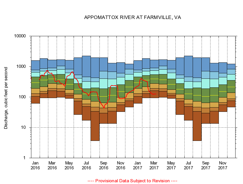
USGS - science for a changing world
Virginia DEQ

Virginia Water Science Center

 
  Duration Plot and Table of 28-Day Average Streamflow
 
02039500 APPOMATTOX RIVER AT FARMVILLE, VA
LOCATION.--Latitude 37°18'25", Longitude 78°23'20", North American Datum of 1927,
                    Cumberland County, VA, Hydrologic Unit 02080207.
DRAINAGE AREA.--302 square miles.
PERIOD OF RECORD.--March 1926 to current year.
DURATION STATISTIC COMPUTATION PERIOD.--All data through September 2015.
REGULATION.--Diurnal fluctuation at low flow caused by mill and disposal plant above station.
GAGE OPERATION.--Virginia Department of Environmental Quality - Water Division.

     Duration Plot with 28-Day Average Streamflow Conditions
Provisional Data Subject to Revision
02039500 plot. 
APPOMATTOX RIVER AT FARMVILLE, VA
Provisional Data Subject to Revision


The current 28-day running-average value for 03/22/2017 is 124.43 cubic feet per second.

  explanation   Percentile Description Duration Plot Description 28 Day 14 Day 7 Day Daily


      Duration Table of 28-Day Average Streamflow
           
Flow values in cubic feet per second


                02039500     APPOMATTOX RIVER AT FARMVILLE, VA

   Minimum daily flow
   5th percentile
 
   10th percentile
 
   25th percentile
 
 
   Median
 
 
   75th percentile


   90th percentile


   95th percentile


   Maximum daily flow
         
Years of record
January
62.1
104
130
190
296
459
642
770
1,570
 
89
February
92.8
131
154
220
362
511
714
854
1,850
 
89
March
93.2
163
193
275
391
542
731
892
1,640
 
89
April
97.5
153
189
267
368
557
805
1,040
1,690
 
89
May
89.8
116
132
177
259
390
626
823
1,620
 
90
June
26.3
74.5
88.9
125
181
278
414
535
1,970
 
90
July
17.1
49.3
59.2
84.0
127
188
324
454
2,220
 
90
August
3.66
33.5
47.1
71.8
115
199
319
425
1,970
 
90
September
13.6
29.7
43.5
64.6
105
188
403
710
1,980
 
90
October
13.6
34.7
46.2
67.0
114
203
395
681
1,290
 
89
November
33.2
55.5
65.7
98.4
150
253
452
612
1,370
 
89
December
46.5
75.6
88.3
138
216
356
559
817
1,220
 
89


The current 28-day running-average value for 03/22/2017 is 124.43 cubic feet per second.

---- Provisional Data Subject to Revision ----

Accessibility FOIA Privacy Policies and Notices

Take Pride in America logo USA.gov logo U.S. Department of the Interior | U.S. Geological Survey
URL: http://va.water.usgs.gov/duration_plots/htm_28/dp02039500.htm
Page Contact Information: Virginia WSC Webmaster
Page Last Modified: 6/19/2016