|
02047500
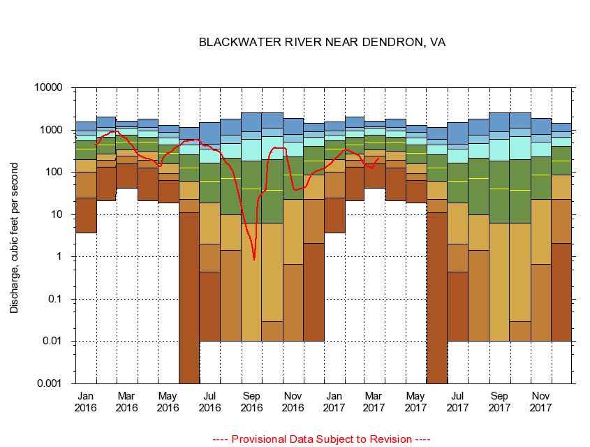
BLACKWATER RIVER NEAR DENDRON, VA
|
Minimum daily flow
|
|
|
5th percentile
|
|
|
|
10th percentile
|
|
|
|
|
25th percentile
|
|
|
|
|
|
Median
|
|
|
|
|
|
|
75th percentile
|
|
|
|
|
|
|
|
90th percentile
|
|
|
|
|
|
|
|
|
95th percentile
|
|
|
|
|
|
|
|
|
|
Maximum daily flow
|
|
|
|
|
|
|
|
|
|
|
|
Years of record
|
January
|
3.65
|
25.0
|
99.5
|
203
|
350
|
563
|
765
|
948
|
1,580
|
|
72
|
February
|
21.2
|
131
|
192
|
274
|
450
|
670
|
935
|
1,160
|
2,010
|
|
72
|
March
|
41.6
|
156
|
237
|
333
|
516
|
747
|
1,100
|
1,190
|
1,640
|
|
72
|
April
|
21.0
|
126
|
193
|
313
|
500
|
682
|
947
|
1,130
|
1,790
|
|
72
|
May
|
18.9
|
63.4
|
92.4
|
159
|
277
|
442
|
660
|
880
|
1,270
|
|
72
|
June
|
0.00
|
10.9
|
22.7
|
60.2
|
128
|
257
|
442
|
611
|
1,130
|
|
72
|
July
|
0.00
|
0.44
|
1.97
|
18.9
|
61.0
|
162
|
350
|
455
|
1,510
|
|
72
|
August
|
0.00
|
0.01
|
1.43
|
9.73
|
72.4
|
217
|
477
|
755
|
1,810
|
|
72
|
September
|
0.00
|
0.00
|
0.00
|
6.17
|
39.7
|
185
|
594
|
915
|
2,520
|
|
73
|
October
|
0.00
|
0.00
|
0.03
|
6.34
|
37.0
|
197
|
692
|
1,100
|
2,580
|
|
72
|
November
|
0.00
|
0.00
|
0.66
|
22.8
|
87.3
|
233
|
520
|
777
|
1,900
|
|
73
|
December
|
0.00
|
2.12
|
22.5
|
85.4
|
185
|
403
|
663
|
899
|
1,420
|
|
73
|
|
|
|