|
02051500
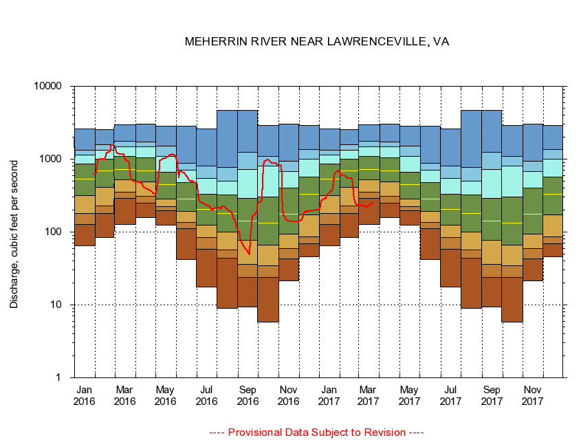
MEHERRIN RIVER NEAR LAWRENCEVILLE, VA
|
Minimum daily flow
|
|
|
5th percentile
|
|
|
|
10th percentile
|
|
|
|
|
25th percentile
|
|
|
|
|
|
Median
|
|
|
|
|
|
|
75th percentile
|
|
|
|
|
|
|
|
90th percentile
|
|
|
|
|
|
|
|
|
95th percentile
|
|
|
|
|
|
|
|
|
|
Maximum daily flow
|
|
|
|
|
|
|
|
|
|
|
|
Years of record
|
January
|
65.3
|
126
|
181
|
315
|
531
|
854
|
1,140
|
1,320
|
2,610
|
|
86
|
February
|
84.6
|
180
|
229
|
413
|
689
|
998
|
1,340
|
1,590
|
2,540
|
|
87
|
March
|
126
|
292
|
356
|
516
|
728
|
1,080
|
1,490
|
1,760
|
2,940
|
|
87
|
April
|
157
|
251
|
312
|
490
|
687
|
1,040
|
1,480
|
1,740
|
3,050
|
|
87
|
May
|
124
|
198
|
225
|
285
|
448
|
667
|
1,090
|
1,500
|
2,830
|
|
87
|
June
|
41.6
|
112
|
136
|
192
|
284
|
478
|
712
|
872
|
2,830
|
|
87
|
July
|
17.7
|
58.7
|
84.7
|
123
|
207
|
331
|
546
|
808
|
2,600
|
|
87
|
August
|
8.94
|
43.4
|
56.5
|
99.9
|
180
|
323
|
502
|
772
|
4,630
|
|
87
|
September
|
9.29
|
23.7
|
36.1
|
76.7
|
142
|
289
|
719
|
1,250
|
4,660
|
|
87
|
October
|
5.75
|
23.6
|
34.5
|
65.5
|
132
|
306
|
806
|
1,080
|
2,870
|
|
86
|
November
|
21.2
|
43.3
|
58.8
|
94.6
|
176
|
401
|
675
|
939
|
3,020
|
|
86
|
December
|
45.3
|
69.6
|
86.8
|
173
|
331
|
572
|
1,010
|
1,360
|
2,880
|
|
86
|
|
|
|