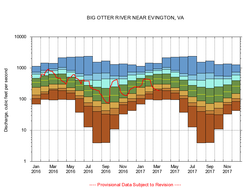
USGS - science for a changing world
Virginia DEQ

Virginia Water Science Center

 
  Duration Plot and Table of 28-Day Average Streamflow
 
02061500 BIG OTTER RIVER NEAR EVINGTON, VA
LOCATION.--Latitude 37°12'30", Longitude 79°18'14", North American Datum of 1927,
                    Campbell County, VA, Hydrologic Unit 03010101
DRAINAGE AREA.--315 square miles.
PERIOD OF RECORD.--October 1936 to current year. Monthly discharge only for some periods, published in WSP 1303. Prior to October 1965, published as Otter River near Evington.
DURATION STATISTIC COMPUTATION PERIOD.--All data through September 2015.
REGULATION.--No known regulation.
GAGE OPERATION.--Virginia Department of Environmental Quality - Water Division.

     Duration Plot with 28-Day Average Streamflow Conditions
Provisional Data Subject to Revision
02061500 plot. 
BIG OTTER RIVER NEAR EVINGTON, VA
Provisional Data Subject to Revision


The current 28-day running-average value for 03/22/2017 is 185.71 cubic feet per second.

  explanation   Percentile Description Duration Plot Description 28 Day 14 Day 7 Day Daily


      Duration Table of 28-Day Average Streamflow
           
Flow values in cubic feet per second


                02061500     BIG OTTER RIVER NEAR EVINGTON, VA

   Minimum daily flow
   5th percentile
 
   10th percentile
 
   25th percentile
 
 
   Median
 
 
   75th percentile


   90th percentile


   95th percentile


   Maximum daily flow
         
Years of record
January
68.8
105
136
238
346
466
632
745
1,140
 
78
February
97.0
149
173
259
400
568
716
836
1,460
 
78
March
94.6
198
216
301
452
640
823
942
1,420
 
78
April
97.3
189
224
302
431
642
905
1,040
2,150
 
78
May
95.4
157
186
232
357
509
730
834
2,210
 
79
June
37.5
105
130
188
275
413
550
655
2,260
 
79
July
12.7
58.9
77.4
118
186
276
414
597
2,410
 
79
August
3.95
40.1
57.9
87.6
143
242
404
673
1,550
 
79
September
4.02
32.8
43.1
72.6
124
224
451
697
1,680
 
79
October
11.0
31.6
51.4
80.7
132
250
447
553
1,300
 
78
November
33.2
66.8
78.6
110
172
293
447
539
1,350
 
78
December
42.6
84.2
104
152
259
393
592
742
1,280
 
78


The current 28-day running-average value for 03/22/2017 is 185.71 cubic feet per second.

---- Provisional Data Subject to Revision ----

Accessibility FOIA Privacy Policies and Notices

Take Pride in America logo USA.gov logo U.S. Department of the Interior | U.S. Geological Survey
URL: http://va.water.usgs.gov/duration_plots/htm_28/dp02061500.htm
Page Contact Information: Virginia WSC Webmaster
Page Last Modified: 6/19/2016