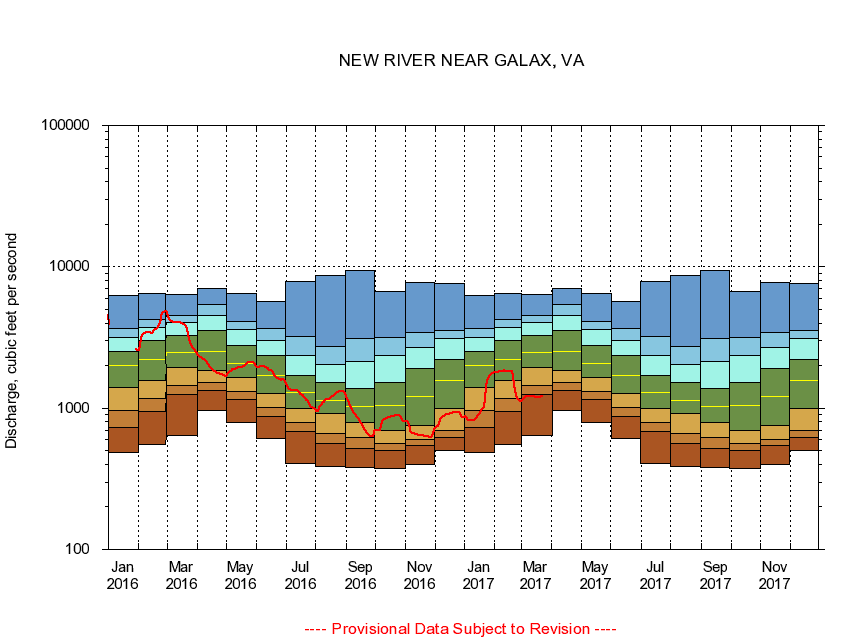
USGS - science for a changing world
Virginia DEQ

Virginia Water Science Center

 
  Duration Plot and Table of 28-Day Average Streamflow
 
03164000 NEW RIVER NEAR GALAX, VA
LOCATION.--Latitude 36°38'50", Longitude 80°58'45", North American Datum of 1927,
                    Grayson County, VA, Hydrologic Unit 05050001.
DRAINAGE AREA.--1,141 square miles.
PERIOD OF RECORD.--October 1929 to current year. Monthly discharge only for some periods, published in WSP 1305.
DURATION STATISTIC COMPUTATION PERIOD.--All data through September 2015.
REGULATION.--Slight diurnal fluctuation at times caused by small hydroelectric dam 36.4 miles above station.
GAGE OPERATION.--U.S. Geological Survey, Virginia Water Science Center.

     Duration Plot with 28-Day Average Streamflow Conditions
Provisional Data Subject to Revision
03164000 plot. 
NEW RIVER NEAR GALAX, VA
Provisional Data Subject to Revision


The current 28-day running-average value for 03/22/2017 is 1209.89 cubic feet per second.

  explanation   Percentile Description Duration Plot Description 28 Day 14 Day 7 Day Daily


      Duration Table of 28-Day Average Streamflow
           
Flow values in cubic feet per second


                03164000     NEW RIVER NEAR GALAX, VA

   Minimum daily flow
   5th percentile
 
   10th percentile
 
   25th percentile
 
 
   Median
 
 
   75th percentile


   90th percentile


   95th percentile


   Maximum daily flow
         
Years of record
January
489
727
958
1,410
1,990
2,530
3,170
3,690
6,240
 
86
February
555
943
1,170
1,570
2,220
3,020
3,700
4,220
6,430
 
86
March
643
1,240
1,440
1,930
2,460
3,260
4,040
4,500
6,360
 
86
April
960
1,330
1,530
1,840
2,520
3,550
4,550
5,410
6,990
 
86
May
789
1,160
1,310
1,660
2,080
2,760
3,590
4,110
6,450
 
86
June
610
873
1,010
1,280
1,690
2,360
2,990
3,650
5,700
 
86
July
403
686
794
993
1,300
1,700
2,370
3,230
7,850
 
86
August
389
565
665
912
1,140
1,530
2,040
2,740
8,740
 
86
September
378
516
624
793
1,020
1,380
2,130
3,090
9,390
 
86
October
376
503
559
692
1,050
1,530
2,370
3,170
6,710
 
85
November
398
542
604
752
1,210
1,900
2,680
3,410
7,750
 
86
December
504
624
690
999
1,560
2,210
3,100
3,550
7,640
 
86


The current 28-day running-average value for 03/22/2017 is 1209.89 cubic feet per second.

---- Provisional Data Subject to Revision ----

Accessibility FOIA Privacy Policies and Notices

Take Pride in America logo USA.gov logo U.S. Department of the Interior | U.S. Geological Survey
URL: http://va.water.usgs.gov/duration_plots/htm_28/dp03164000.htm
Page Contact Information: Virginia WSC Webmaster
Page Last Modified: 6/19/2016