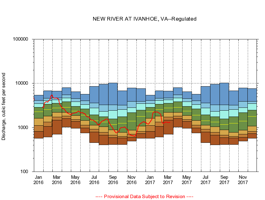
USGS - science for a changing world
Virginia DEQ

Virginia Water Science Center

 
  Duration Plot and Table of 28-Day Average Streamflow
 
03165500 NEW RIVER AT IVANHOE, VA
LOCATION.--Latitude 36°50'05", Longitude 80°57'10", North American Datum of 1927,
                    Wythe County, VA, Hydrologic Unit 05050001.
DRAINAGE AREA.--1,350 square miles.
PERIOD OF RECORD.--August to December 1927, October 1929 to September 1978, February 1996 to current year. Monthly discharge only for some periods, published in WSP 1305. Gage-height records collected in vicinity, October 1916 to July 1943, are contained in reports of the National Weather Service.
DURATION STATISTIC COMPUTATION PERIOD.--All data through September 2015.
REGULATION.--Flow regulated by powerplants about 2.8 and 5.5 miles upstream.
GAGE OPERATION.--U.S. Geological Survey, Virginia Water Science Center.

     Duration Plot with 28-Day Average Streamflow Conditions
Provisional Data Subject to Revision
03165500 plot. 
NEW RIVER AT IVANHOE, VA
Provisional Data Subject to Revision


The current 28-day running-average value for 03/22/2017 is 1309.25 cubic feet per second.

  explanation   Percentile Description Duration Plot Description 28 Day 14 Day 7 Day Daily


      Duration Table of 28-Day Average Streamflow
           
Flow values in cubic feet per second


                03165500     NEW RIVER AT IVANHOE, VA

   Minimum daily flow
   5th percentile
 
   10th percentile
 
   25th percentile
 
 
   Median
 
 
   75th percentile


   90th percentile


   95th percentile


   Maximum daily flow
         
Years of record
January
575
821
1,120
1,620
2,270
2,870
3,470
4,100
5,400
 
68
February
613
1,070
1,340
1,820
2,540
3,360
4,100
4,600
6,780
 
68
March
710
1,470
1,730
2,210
2,790
3,520
4,270
4,660
6,660
 
69
April
1,030
1,590
1,830
2,220
2,850
3,840
4,700
5,490
7,940
 
69
May
957
1,380
1,530
1,880
2,350
3,000
3,820
4,520
6,520
 
69
June
760
971
1,130
1,450
1,900
2,640
3,330
4,020
5,720
 
69
July
455
795
911
1,130
1,430
1,930
2,760
3,580
8,540
 
69
August
403
674
780
1,050
1,330
1,760
2,310
3,250
9,540
 
69
September
412
594
670
889
1,170
1,580
2,430
3,250
10,300
 
70
October
415
581
629
778
1,240
1,770
2,540
3,210
6,810
 
68
November
491
603
701
879
1,410
2,160
2,840
3,910
7,830
 
69
December
568
731
812
1,080
1,780
2,480
3,460
3,880
7,590
 
69


The current 28-day running-average value for 03/22/2017 is 1309.25 cubic feet per second.

---- Provisional Data Subject to Revision ----

Accessibility FOIA Privacy Policies and Notices

Take Pride in America logo USA.gov logo U.S. Department of the Interior | U.S. Geological Survey
URL: http://va.water.usgs.gov/duration_plots/htm_28/dp03165500.htm
Page Contact Information: Virginia WSC Webmaster
Page Last Modified: 6/19/2016