|
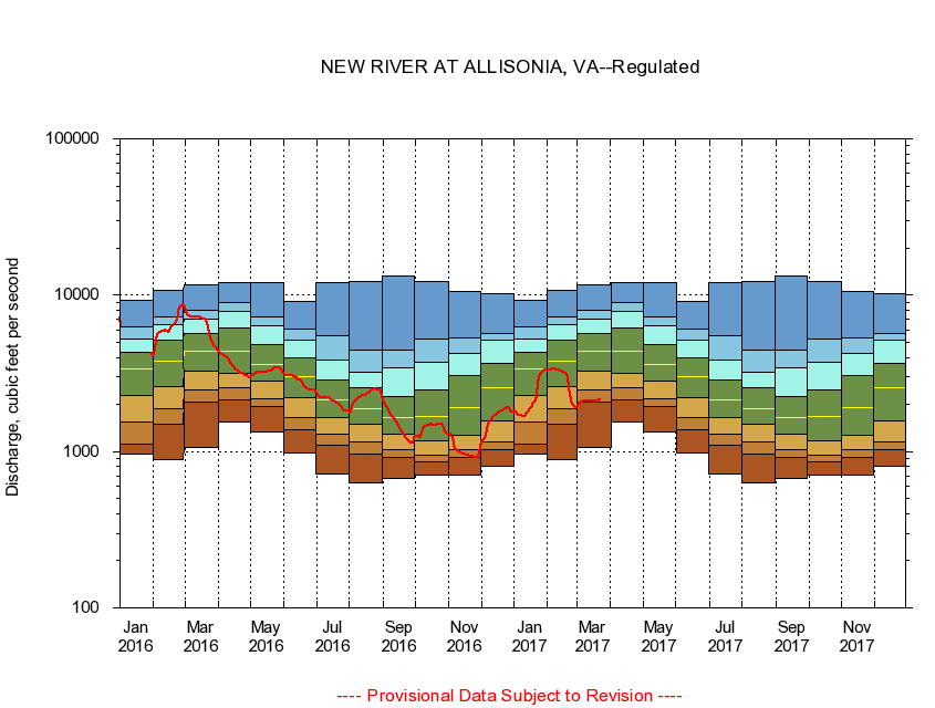
03168000
NEW RIVER AT ALLISONIA, VA
|
Minimum daily flow
|
|
|
5th percentile
|
|
|
|
10th percentile
|
|
|
|
|
25th percentile
|
|
|
|
|
|
Median
|
|
|
|
|
|
|
75th percentile
|
|
|
|
|
|
|
|
90th percentile
|
|
|
|
|
|
|
|
|
95th percentile
|
|
|
|
|
|
|
|
|
|
Maximum daily flow
|
|
|
|
|
|
|
|
|
|
|
|
Years of record
|
January
|
957
|
1,120
|
1,540
|
2,270
|
3,350
|
4,310
|
5,210
|
6,310
|
9,320
|
|
86
|
February
|
894
|
1,500
|
1,890
|
2,620
|
3,800
|
5,150
|
6,480
|
7,200
|
10,800
|
|
86
|
March
|
1,070
|
2,060
|
2,480
|
3,280
|
4,380
|
5,730
|
6,990
|
7,950
|
11,600
|
|
86
|
April
|
1,540
|
2,150
|
2,560
|
3,170
|
4,350
|
6,200
|
7,840
|
9,030
|
12,100
|
|
86
|
May
|
1,330
|
1,930
|
2,190
|
2,840
|
3,590
|
4,860
|
6,400
|
7,200
|
12,000
|
|
86
|
June
|
976
|
1,380
|
1,650
|
2,220
|
2,990
|
4,000
|
5,130
|
6,090
|
9,130
|
|
86
|
July
|
719
|
1,090
|
1,300
|
1,650
|
2,150
|
2,860
|
3,850
|
5,530
|
12,000
|
|
86
|
August
|
632
|
964
|
1,160
|
1,500
|
1,870
|
2,550
|
3,240
|
4,420
|
12,300
|
|
86
|
September
|
670
|
924
|
1,030
|
1,300
|
1,650
|
2,230
|
3,450
|
4,420
|
13,300
|
|
86
|
October
|
703
|
864
|
953
|
1,180
|
1,670
|
2,490
|
3,750
|
5,280
|
12,200
|
|
85
|
November
|
703
|
917
|
1,020
|
1,260
|
1,920
|
3,050
|
4,230
|
5,340
|
10,600
|
|
86
|
December
|
808
|
1,020
|
1,150
|
1,580
|
2,550
|
3,660
|
5,190
|
5,730
|
10,300
|
|
86
|
|
|
|