|
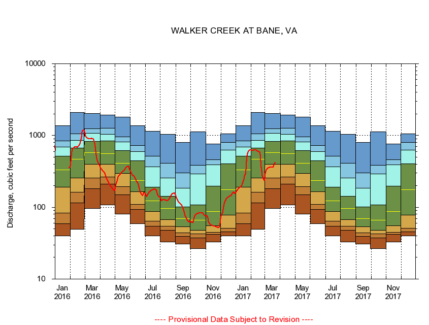
03173000
WALKER CREEK AT BANE, VA
|
Minimum daily flow
|
|
|
5th percentile
|
|
|
|
10th percentile
|
|
|
|
|
25th percentile
|
|
|
|
|
|
Median
|
|
|
|
|
|
|
75th percentile
|
|
|
|
|
|
|
|
90th percentile
|
|
|
|
|
|
|
|
|
95th percentile
|
|
|
|
|
|
|
|
|
|
Maximum daily flow
|
|
|
|
|
|
|
|
|
|
|
|
Years of record
|
January
|
40.1
|
59.1
|
83.7
|
191
|
334
|
513
|
694
|
845
|
1,370
|
|
77
|
February
|
49.0
|
116
|
163
|
254
|
468
|
670
|
859
|
1,050
|
2,110
|
|
77
|
March
|
95.6
|
183
|
256
|
396
|
582
|
830
|
1,080
|
1,240
|
2,030
|
|
77
|
April
|
108
|
210
|
263
|
398
|
557
|
834
|
1,040
|
1,270
|
1,930
|
|
77
|
May
|
80.8
|
149
|
193
|
295
|
413
|
612
|
809
|
960
|
1,810
|
|
78
|
June
|
58.6
|
92.5
|
110
|
165
|
237
|
447
|
599
|
720
|
1,360
|
|
78
|
July
|
39.8
|
54.1
|
63.8
|
86.6
|
122
|
190
|
369
|
517
|
1,150
|
|
78
|
August
|
33.1
|
48.0
|
54.0
|
67.5
|
96.4
|
143
|
257
|
411
|
1,040
|
|
78
|
September
|
30.6
|
39.5
|
44.3
|
53.2
|
69.3
|
101
|
185
|
303
|
804
|
|
78
|
October
|
26.7
|
37.6
|
42.9
|
47.8
|
65.8
|
108
|
292
|
385
|
1,120
|
|
77
|
November
|
32.7
|
42.2
|
44.5
|
55.3
|
87.9
|
196
|
391
|
458
|
764
|
|
77
|
December
|
40.1
|
45.2
|
51.0
|
78.5
|
176
|
401
|
622
|
804
|
1,060
|
|
77
|
|
|
|