|
03488000
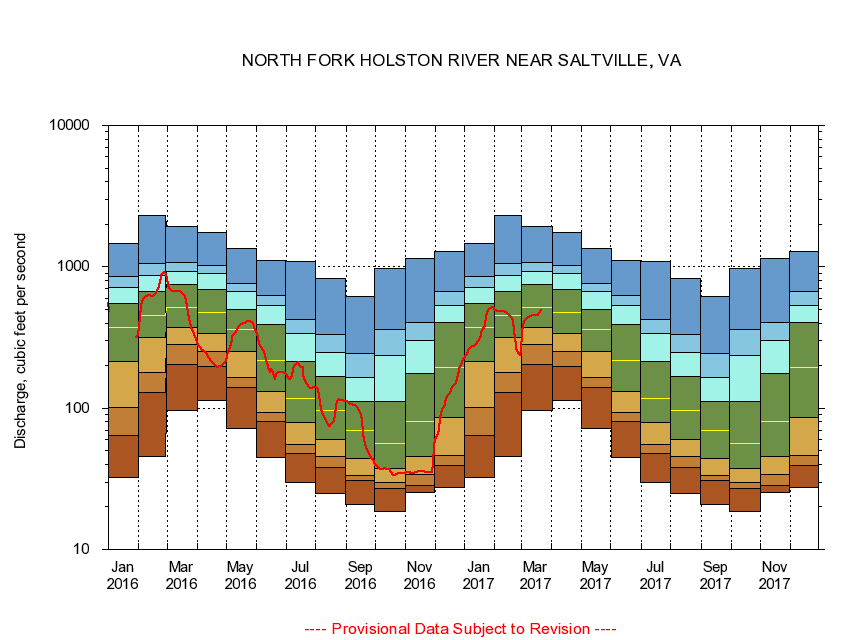
NORTH FORK HOLSTON RIVER NEAR SALTVILLE, VA
|
Minimum daily flow
|
|
|
5th percentile
|
|
|
|
10th percentile
|
|
|
|
|
25th percentile
|
|
|
|
|
|
Median
|
|
|
|
|
|
|
75th percentile
|
|
|
|
|
|
|
|
90th percentile
|
|
|
|
|
|
|
|
|
95th percentile
|
|
|
|
|
|
|
|
|
|
Maximum daily flow
|
|
|
|
|
|
|
|
|
|
|
|
Years of record
|
January
|
32.3
|
63.8
|
101
|
214
|
372
|
553
|
719
|
852
|
1,470
|
|
96
|
February
|
45.6
|
129
|
179
|
314
|
451
|
672
|
865
|
1,060
|
2,320
|
|
96
|
March
|
95.7
|
205
|
281
|
375
|
518
|
751
|
932
|
1,070
|
1,930
|
|
96
|
April
|
113
|
197
|
253
|
335
|
472
|
696
|
897
|
1,030
|
1,740
|
|
96
|
May
|
72.2
|
140
|
164
|
252
|
358
|
502
|
671
|
766
|
1,340
|
|
96
|
June
|
44.7
|
80.3
|
93.4
|
131
|
219
|
394
|
529
|
622
|
1,100
|
|
96
|
July
|
29.6
|
47.5
|
55.4
|
78.9
|
117
|
213
|
339
|
421
|
1,090
|
|
97
|
August
|
25.1
|
37.8
|
45.6
|
59.8
|
97.0
|
167
|
246
|
331
|
825
|
|
97
|
September
|
20.9
|
30.9
|
33.6
|
44.1
|
69.8
|
111
|
166
|
242
|
616
|
|
97
|
October
|
18.5
|
27.0
|
29.6
|
37.4
|
56.1
|
111
|
236
|
359
|
966
|
|
96
|
November
|
25.4
|
28.4
|
34.0
|
45.7
|
79.9
|
175
|
302
|
404
|
1,140
|
|
97
|
December
|
27.6
|
39.4
|
46.3
|
85.3
|
194
|
403
|
531
|
664
|
1,280
|
|
97
|
|
|
|