|
03527000
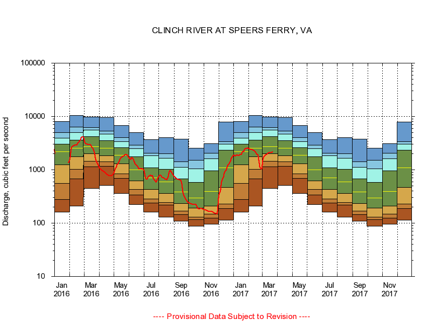
CLINCH RIVER AT SPEERS FERRY, VA
|
Minimum daily flow
|
|
|
5th percentile
|
|
|
|
10th percentile
|
|
|
|
|
25th percentile
|
|
|
|
|
|
Median
|
|
|
|
|
|
|
75th percentile
|
|
|
|
|
|
|
|
90th percentile
|
|
|
|
|
|
|
|
|
95th percentile
|
|
|
|
|
|
|
|
|
|
Maximum daily flow
|
|
|
|
|
|
|
|
|
|
|
|
Years of record
|
January
|
161
|
279
|
562
|
1,250
|
2,170
|
3,050
|
3,890
|
4,970
|
8,070
|
|
73
|
February
|
208
|
676
|
1,030
|
1,760
|
2,540
|
3,640
|
5,000
|
6,290
|
10,500
|
|
73
|
March
|
448
|
1,130
|
1,440
|
2,000
|
2,690
|
4,200
|
5,540
|
6,230
|
9,890
|
|
73
|
April
|
513
|
1,160
|
1,420
|
1,830
|
2,530
|
3,510
|
4,700
|
5,280
|
9,660
|
|
73
|
May
|
357
|
688
|
849
|
1,300
|
1,860
|
2,590
|
3,360
|
3,990
|
6,790
|
|
73
|
June
|
221
|
339
|
428
|
616
|
1,010
|
1,760
|
2,470
|
2,900
|
4,970
|
|
73
|
July
|
161
|
241
|
281
|
430
|
711
|
1,090
|
1,820
|
2,040
|
3,680
|
|
73
|
August
|
130
|
217
|
244
|
359
|
593
|
1,030
|
1,660
|
2,020
|
4,020
|
|
73
|
September
|
108
|
145
|
170
|
235
|
384
|
676
|
1,120
|
1,410
|
3,750
|
|
73
|
October
|
88.0
|
116
|
129
|
192
|
299
|
581
|
1,050
|
1,500
|
2,550
|
|
71
|
November
|
95.7
|
125
|
149
|
211
|
396
|
949
|
1,630
|
2,070
|
3,080
|
|
73
|
December
|
115
|
186
|
229
|
471
|
1,100
|
2,340
|
3,010
|
3,350
|
7,820
|
|
73
|
|
|
|