USGS - science for a changing world
Virginia DEQ

Virginia Water Science Center

 
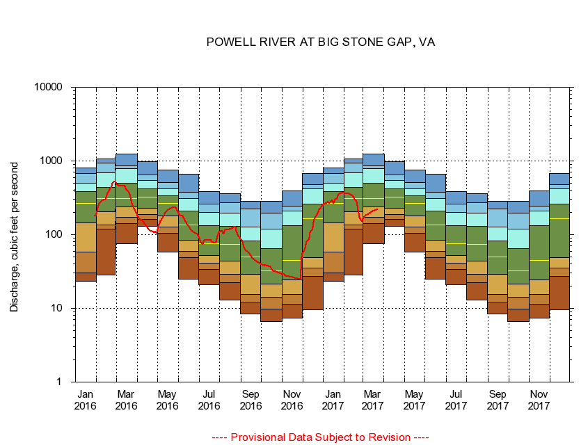
  Duration Plot and Table of 28-Day Average Streamflow
 
03529500 POWELL RIVER AT BIG STONE GAP, VA
LOCATION.--Latitude 36°52'08", Longitude 82°46'32", North American Datum of 1927,
                    Wise County, VA, Hydrologic Unit 06010206
DRAINAGE AREA.--112 square miles.
PERIOD OF RECORD.--October 1944 to September 1959, October 1978 to September 1981, October 2001 to current year.
DURATION STATISTIC COMPUTATION PERIOD.--All data through September 2015.
REGULATION.--No known regulation.
GAGE OPERATION.--U.S. Geological Survey, Virginia Water Science Center.

     Duration Plot with 28-Day Average Streamflow Conditions
Provisional Data Subject to Revision
03529500 plot. 
POWELL RIVER AT BIG STONE GAP, VA
Provisional Data Subject to Revision


The current 28-day running-average value for 03/22/2017 is 217.96 cubic feet per second.

  explanation   Percentile Description Duration Plot Description 28 Day 14 Day 7 Day Daily


      Duration Table of 28-Day Average Streamflow
           
Flow values in cubic feet per second


                03529500     POWELL RIVER AT BIG STONE GAP, VA

   Minimum daily flow
   5th percentile
 
   10th percentile
 
   25th percentile
 
 
   Median
 
 
   75th percentile


   90th percentile


   95th percentile


   Maximum daily flow
         
Years of record
January
23.1
30.5
57.7
146
264
382
499
670
803
 
32
February
28.5
118
137
204
310
438
686
927
1,060
 
32
March
75.0
142
172
236
312
501
794
853
1,230
 
32
April
129
162
186
230
324
418
550
649
986
 
32
May
57.9
104
126
180
264
335
423
506
760
 
32
June
25.0
48.8
59.2
84.3
137
208
307
373
656
 
32
July
21.0
34.1
41.3
52.1
75.4
133
200
259
386
 
32
August
13.1
22.3
29.0
43.9
74.4
130
195
269
364
 
32
September
8.32
11.8
15.3
29.0
50.2
82.2
128
222
281
 
32
October
6.64
9.69
14.3
21.6
32.5
64.5
118
197
283
 
29
November
7.33
11.3
15.3
24.6
44.9
134
211
242
395
 
32
December
9.58
27.3
35.2
48.7
165
261
420
481
678
 
32


The current 28-day running-average value for 03/22/2017 is 217.96 cubic feet per second.

---- Provisional Data Subject to Revision ----

Accessibility FOIA Privacy Policies and Notices

Take Pride in America logo USA.gov logo U.S. Department of the Interior | U.S. Geological Survey
URL: http://va.water.usgs.gov/duration_plots/htm_28/dp03529500.htm
Page Contact Information: Virginia WSC Webmaster
Page Last Modified: 6/19/2016