|
03531500
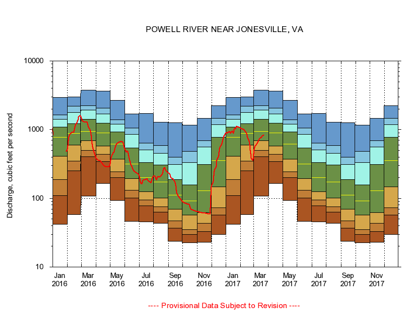
POWELL RIVER NEAR JONESVILLE, VA
|
Minimum daily flow
|
|
|
5th percentile
|
|
|
|
10th percentile
|
|
|
|
|
25th percentile
|
|
|
|
|
|
Median
|
|
|
|
|
|
|
75th percentile
|
|
|
|
|
|
|
|
90th percentile
|
|
|
|
|
|
|
|
|
95th percentile
|
|
|
|
|
|
|
|
|
|
Maximum daily flow
|
|
|
|
|
|
|
|
|
|
|
|
Years of record
|
January
|
41.9
|
109
|
188
|
413
|
769
|
1,090
|
1,410
|
1,650
|
2,940
|
|
84
|
February
|
58.2
|
252
|
348
|
600
|
883
|
1,230
|
1,790
|
2,210
|
3,000
|
|
84
|
March
|
108
|
401
|
500
|
688
|
935
|
1,410
|
1,920
|
2,220
|
3,750
|
|
84
|
April
|
164
|
344
|
436
|
577
|
899
|
1,240
|
1,680
|
2,070
|
3,650
|
|
84
|
May
|
93.8
|
199
|
245
|
373
|
617
|
924
|
1,210
|
1,400
|
2,670
|
|
84
|
June
|
46.1
|
101
|
131
|
195
|
318
|
539
|
859
|
1,050
|
1,690
|
|
84
|
July
|
45.8
|
77.3
|
94.5
|
124
|
202
|
333
|
511
|
637
|
1,710
|
|
84
|
August
|
43.0
|
62.8
|
75.4
|
101
|
174
|
304
|
450
|
585
|
1,290
|
|
84
|
September
|
23.8
|
36.7
|
47.0
|
69.3
|
112
|
187
|
311
|
397
|
1,270
|
|
84
|
October
|
22.5
|
29.9
|
34.8
|
57.1
|
91.5
|
158
|
330
|
483
|
1,160
|
|
83
|
November
|
22.9
|
32.6
|
43.4
|
62.1
|
129
|
311
|
559
|
695
|
1,470
|
|
84
|
December
|
30.0
|
57.3
|
72.9
|
146
|
357
|
776
|
1,190
|
1,460
|
2,220
|
|
84
|
|
|
|