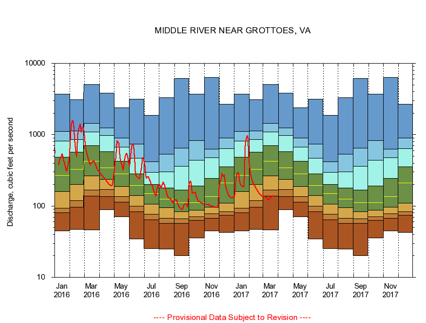
USGS - science for a changing world
Virginia DEQ

Virginia Water Science Center

 
  Duration Plot and Table of 7-Day Average Streamflow
 
01625000 MIDDLE RIVER NEAR GROTTOES, VA
LOCATION.--Latitude 38°15'42", Longitude 78°51'44", North American Datum of 1927,
                    Augusta County, VA, Hydrologic Unit 02070005.
DRAINAGE AREA.--373 square miles.
PERIOD OF RECORD.--April 1927 to current year. Records for February 1925 to September 1926, published in WSP 601 and 621, are unreliable and should not be used.
DURATION STATISTIC COMPUTATION PERIOD.--All data through September 2015.
REGULATION.--Some small diurnal fluctuation at low flow caused by mills upstream. Discharge includes discharges at treatment plants upstream, much of which is diverted from another drainage basin for industrial and municipal supply. Wastwater treatment upstream estimated input 6.4 cfs.
GAGE OPERATION.--Virginia Department of Environmental Quality - Water Division.

     Duration Plot with 7-Day Average Streamflow Conditions
Provisional Data Subject to Revision
01625000 plot. 
MIDDLE RIVER NEAR GROTTOES, VA
Provisional Data Subject to Revision


The current 7-day running-average value for 03/22/2017 is 136 cubic feet per second.

  explanation   Percentile Description Duration Plot Description 28 Day 14 Day 7 Day Daily


      Duration Table of 7-Day Average Streamflow
           
Flow values in cubic feet per second


                01625000     MIDDLE RIVER NEAR GROTTOES, VA

   Minimum daily flow
   5th percentile
 
   10th percentile
 
   25th percentile
 
 
   Median
 
 
   75th percentile


   90th percentile


   95th percentile


   Maximum daily flow
         
Years of record
January
45.1
80.7
92.8
159
269
480
816
1,100
3,690
 
88
February
47.0
97.0
119
202
328
564
859
1,130
3,070
 
88
March
46.1
138
168
264
424
702
1,090
1,450
5,040
 
88
April
89.3
136
169
234
342
574
981
1,240
3,830
 
88
May
71.0
114
136
188
284
426
674
893
2,380
 
88
June
34.3
83.4
99.4
139
194
283
467
736
3,170
 
88
July
25.3
64.2
76.8
106
149
201
295
414
1,860
 
88
August
24.9
57.4
67.7
94.0
125
179
303
534
3,320
 
88
September
20.1
57.6
66.4
83.6
111
167
360
650
6,180
 
88
October
35.9
63.3
70.3
87.4
111
191
435
829
3,730
 
87
November
44.6
67.7
78.3
95.7
135
245
473
626
6,380
 
88
December
42.7
73.9
83.4
110
209
357
638
892
2,680
 
88


The current 7-day running-average value for 03/22/2017 is 136 cubic feet per second.

---- Provisional Data Subject to Revision ----

Accessibility FOIA Privacy Policies and Notices

Take Pride in America logo USA.gov logo U.S. Department of the Interior | U.S. Geological Survey
URL: http://va.water.usgs.gov/duration_plots/htm_7/dp01625000.htm
Page Contact Information: Virginia WSC Webmaster
Page Last Modified: 6/19/2016