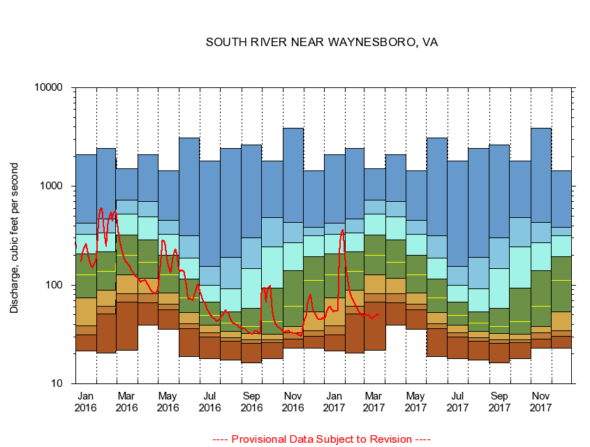
USGS - science for a changing world
Virginia DEQ

Virginia Water Science Center

 
  Duration Plot and Table of 7-Day Average Streamflow
 
01626000 SOUTH RIVER NEAR WAYNESBORO, VA
LOCATION.--Latitude 38°03'27", Longitude 78°54'30", North American Datum of 1927,
                    Waynesboro City, VA, Hydrologic Unit 02070005.
DRAINAGE AREA.--127 square miles, of which 41 square miles are above flood-detention structures.
PERIOD OF RECORD.--October 1952 to current year.
DURATION STATISTIC COMPUTATION PERIOD.--All data through September 2015.
REGULATION.--Wastwater treatment upstream estimated input 6.1 cfs.
GAGE OPERATION.--Virginia Department of Environmental Quality - Water Division.

     Duration Plot with 7-Day Average Streamflow Conditions
Provisional Data Subject to Revision
01626000 plot. 
SOUTH RIVER NEAR WAYNESBORO, VA
Provisional Data Subject to Revision


The current 7-day running-average value for 03/22/2017 is 49.57 cubic feet per second.

  explanation   Percentile Description Duration Plot Description 28 Day 14 Day 7 Day Daily


      Duration Table of 7-Day Average Streamflow
           
Flow values in cubic feet per second


                01626000     SOUTH RIVER NEAR WAYNESBORO, VA

   Minimum daily flow
   5th percentile
 
   10th percentile
 
   25th percentile
 
 
   Median
 
 
   75th percentile


   90th percentile


   95th percentile


   Maximum daily flow
         
Years of record
January
21.4
31.4
38.4
74.7
127
208
328
426
2,090
 
63
February
20.6
50.9
60.7
89.4
137
217
340
469
2,430
 
63
March
22.0
67.0
82.3
126
202
319
521
725
1,500
 
63
April
39.3
66.1
81.7
118
170
286
489
697
2,100
 
63
May
35.6
56.3
64.0
83.6
126
200
327
451
1,450
 
63
June
18.9
36.3
40.9
53.1
74.5
115
188
318
3,080
 
63
July
17.9
29.9
32.7
39.6
49.7
67.6
98.9
155
1,820
 
63
August
17.4
27.0
29.3
33.9
41.4
53.7
91.9
190
2,440
 
63
September
16.4
25.7
28.0
32.1
38.3
58.4
148
301
2,610
 
63
October
17.9
26.0
27.9
32.0
42.4
93.9
244
486
1,820
 
62
November
23.1
28.4
32.7
38.1
61.0
139
269
433
3,910
 
63
December
23.0
30.3
34.4
53.9
111
194
314
385
1,440
 
63


The current 7-day running-average value for 03/22/2017 is 49.57 cubic feet per second.

---- Provisional Data Subject to Revision ----

Accessibility FOIA Privacy Policies and Notices

Take Pride in America logo USA.gov logo U.S. Department of the Interior | U.S. Geological Survey
URL: http://va.water.usgs.gov/duration_plots/htm_7/dp01626000.htm
Page Contact Information: Virginia WSC Webmaster
Page Last Modified: 6/19/2016