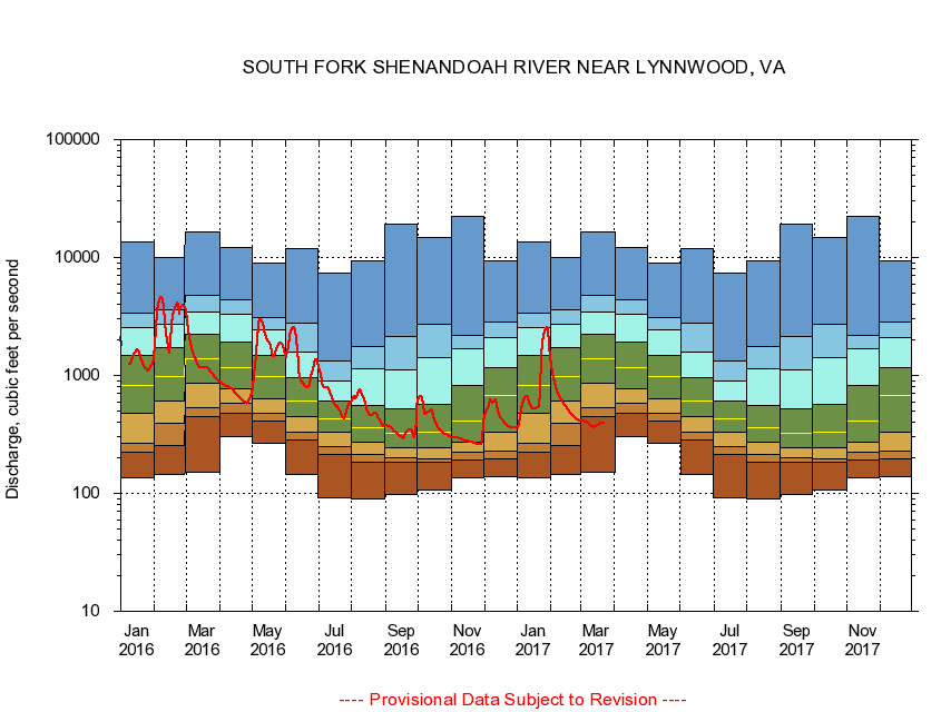
USGS - science for a changing world
Virginia DEQ

Virginia Water Science Center

 
  Duration Plot and Table of 7-Day Average Streamflow
 
01628500 SOUTH FORK SHENANDOAH RIVER NEAR LYNNWOOD, VA
LOCATION.--Latitude 38°19'21", Longitude 78°45'18", North American Datum of 1927,
                    Rockingham County, VA, Hydrologic Unit 02070005.
DRAINAGE AREA.--1,079 square miles.
PERIOD OF RECORD.--September 1930 to current year.
DURATION STATISTIC COMPUTATION PERIOD.--All data through September 2015.
REGULATION.--Diurnal fluctuation at low flow prior to 1960 caused by mill at Lynnwood and since by irrigation during summer months.
GAGE OPERATION.--Virginia Department of Environmental Quality - Water Division.

     Duration Plot with 7-Day Average Streamflow Conditions
Provisional Data Subject to Revision
01628500 plot. 
SOUTH FORK SHENANDOAH RIVER NEAR LYNNWOOD, VA
Provisional Data Subject to Revision


The current 7-day running-average value for 03/22/2017 is 396.86 cubic feet per second.

  explanation   Percentile Description Duration Plot Description 28 Day 14 Day 7 Day Daily


      Duration Table of 7-Day Average Streamflow
           
Flow values in cubic feet per second


                01628500     SOUTH FORK SHENANDOAH RIVER NEAR LYNNWOOD, VA

   Minimum daily flow
   5th percentile
 
   10th percentile
 
   25th percentile
 
 
   Median
 
 
   75th percentile


   90th percentile


   95th percentile


   Maximum daily flow
         
Years of record
January
137
223
268
474
826
1,470
2,560
3,350
13,600
 
85
February
145
257
395
611
983
1,710
2,730
3,570
10,000
 
85
March
151
443
535
860
1,380
2,220
3,480
4,760
16,600
 
85
April
301
473
582
777
1,160
1,900
3,330
4,390
12,200
 
85
May
268
409
474
640
972
1,480
2,420
3,100
8,950
 
85
June
145
286
333
451
610
950
1,580
2,780
11,900
 
85
July
91.0
212
248
327
430
607
893
1,330
7,450
 
85
August
89.6
184
215
273
363
562
1,140
1,750
9,310
 
85
September
98.9
183
199
243
323
519
1,110
2,120
19,000
 
85
October
106
182
194
243
331
568
1,420
2,720
14,900
 
84
November
135
191
222
270
408
823
1,670
2,190
22,500
 
85
December
138
196
230
330
670
1,160
2,100
2,810
9,420
 
85


The current 7-day running-average value for 03/22/2017 is 396.86 cubic feet per second.

---- Provisional Data Subject to Revision ----

Accessibility FOIA Privacy Policies and Notices

Take Pride in America logo USA.gov logo U.S. Department of the Interior | U.S. Geological Survey
URL: http://va.water.usgs.gov/duration_plots/htm_7/dp01628500.htm
Page Contact Information: Virginia WSC Webmaster
Page Last Modified: 6/19/2016