|
01633000
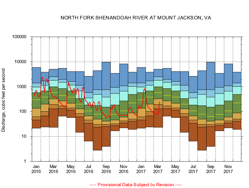
NORTH FORK SHENANDOAH RIVER AT MOUNT JACKSON, VA
|
Minimum daily flow
|
|
|
5th percentile
|
|
|
|
10th percentile
|
|
|
|
|
25th percentile
|
|
|
|
|
|
Median
|
|
|
|
|
|
|
75th percentile
|
|
|
|
|
|
|
|
90th percentile
|
|
|
|
|
|
|
|
|
95th percentile
|
|
|
|
|
|
|
|
|
|
Maximum daily flow
|
|
|
|
|
|
|
|
|
|
|
|
Years of record
|
January
|
21.6
|
46.0
|
61.9
|
137
|
299
|
568
|
965
|
1,410
|
5,980
|
|
72
|
February
|
24.1
|
66.6
|
100
|
201
|
378
|
680
|
1,140
|
1,690
|
3,880
|
|
72
|
March
|
23.3
|
128
|
193
|
321
|
568
|
998
|
1,790
|
2,520
|
5,060
|
|
72
|
April
|
65.1
|
134
|
171
|
271
|
443
|
830
|
1,500
|
1,940
|
5,510
|
|
72
|
May
|
57.7
|
116
|
141
|
217
|
380
|
684
|
1,180
|
1,620
|
4,010
|
|
72
|
June
|
14.6
|
62.0
|
83.3
|
128
|
200
|
335
|
670
|
1,130
|
4,010
|
|
72
|
July
|
6.54
|
34.1
|
45.9
|
67.9
|
106
|
183
|
356
|
571
|
2,660
|
|
72
|
August
|
2.84
|
23.7
|
30.5
|
49.9
|
79.4
|
173
|
482
|
758
|
4,460
|
|
72
|
September
|
4.00
|
25.4
|
30.4
|
41.4
|
64.1
|
153
|
379
|
745
|
9,640
|
|
72
|
October
|
17.0
|
27.7
|
32.1
|
45.6
|
77.1
|
182
|
534
|
948
|
3,470
|
|
71
|
November
|
22.1
|
35.2
|
42.0
|
59.6
|
108
|
267
|
662
|
1,070
|
8,290
|
|
72
|
December
|
19.4
|
41.7
|
50.5
|
89.3
|
225
|
483
|
1,010
|
1,390
|
3,840
|
|
72
|
|
|
|