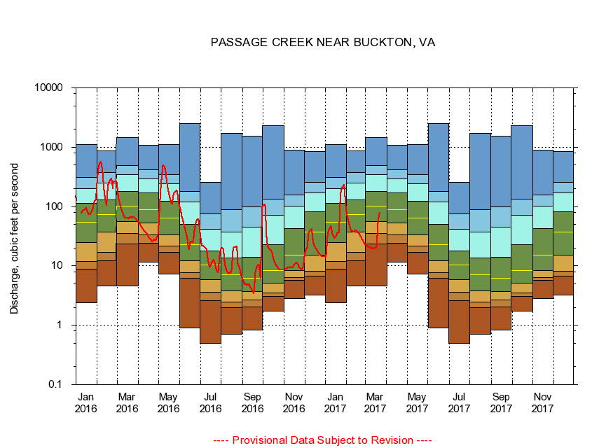
USGS - science for a changing world
Virginia DEQ

Virginia Water Science Center

 
  Duration Plot and Table of 7-Day Average Streamflow
 
01635500 PASSAGE CREEK NEAR BUCKTON, VA
LOCATION.--Latitude 38°57'29", Longitude 78°16'01", North American Datum of 1927,
                    Warren County, VA, Hydrologic Unit 02070006.
DRAINAGE AREA.--86.5 square miles.
PERIOD OF RECORD.--October 1905 to July 1906 (gage heights only), April 1932 to current year. Prior to October 1966 published as "at Buckton."
DURATION STATISTIC COMPUTATION PERIOD.--All data through September 2015.
REGULATION.--Some regulation at low flows from operation of State Fish Hatchery 2 miles above station. At a point 14.2 miles upstream from gage on Little Passage Creek, there was a diversion at times of about 0.36 cfs (1991).
GAGE OPERATION.--Virginia Department of Environmental Quality - Water Division.

     Duration Plot with 7-Day Average Streamflow Conditions
Provisional Data Subject to Revision
01635500 plot. 
PASSAGE CREEK NEAR BUCKTON, VA
Provisional Data Subject to Revision


The current 7-day running-average value for 03/22/2017 is 77.29 cubic feet per second.

  explanation   Percentile Description Duration Plot Description 28 Day 14 Day 7 Day Daily


      Duration Table of 7-Day Average Streamflow
           
Flow values in cubic feet per second


                01635500     PASSAGE CREEK NEAR BUCKTON, VA

   Minimum daily flow
   5th percentile
 
   10th percentile
 
   25th percentile
 
 
   Median
 
 
   75th percentile


   90th percentile


   95th percentile


   Maximum daily flow
         
Years of record
January
2.41
8.85
12.0
24.9
53.7
112
203
313
1,110
 
83
February
4.59
12.2
17.0
36.9
74.2
129
247
375
858
 
83
March
4.59
23.7
34.9
55.6
101
180
349
494
1,440
 
83
April
11.7
23.9
33.4
53.0
89.2
172
296
413
1,080
 
83
May
7.21
16.8
21.7
33.1
64.9
124
241
349
1,100
 
84
June
0.91
6.17
7.81
12.3
22.9
50.1
120
180
2,470
 
84
July
0.50
2.63
3.57
5.86
10.4
18.0
41.0
75.4
253
 
84
August
0.71
1.96
2.44
3.80
7.03
13.6
37.1
88.7
1,710
 
84
September
0.83
2.04
2.66
3.73
6.21
13.9
44.9
98.3
1,520
 
84
October
1.74
3.07
3.53
5.16
8.39
23.1
71.5
134
2,320
 
83
November
2.84
5.74
6.40
8.42
15.0
42.6
103
158
898
 
83
December
3.23
6.75
8.15
15.0
37.7
82.1
171
255
856
 
83


The current 7-day running-average value for 03/22/2017 is 77.29 cubic feet per second.

---- Provisional Data Subject to Revision ----

Accessibility FOIA Privacy Policies and Notices

Take Pride in America logo USA.gov logo U.S. Department of the Interior | U.S. Geological Survey
URL: http://va.water.usgs.gov/duration_plots/htm_7/dp01635500.htm
Page Contact Information: Virginia WSC Webmaster
Page Last Modified: 6/19/2016