|
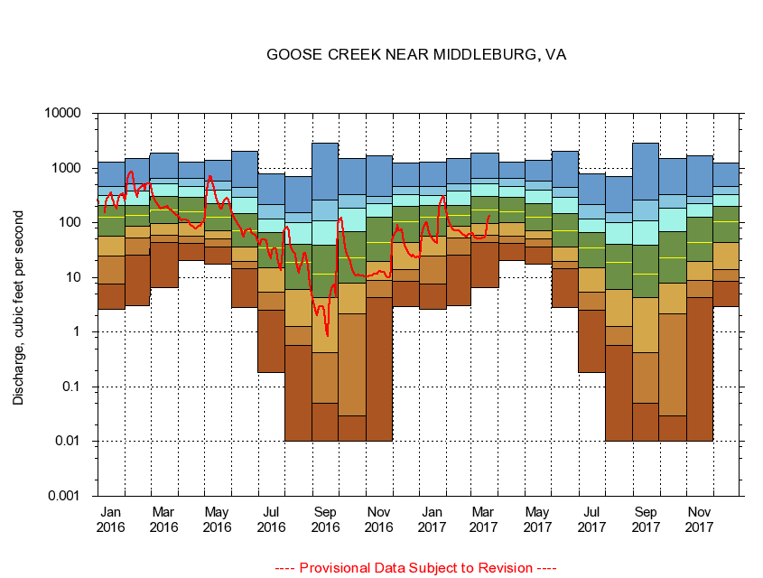
01643700
GOOSE CREEK NEAR MIDDLEBURG, VA
|
Minimum daily flow
|
|
|
5th percentile
|
|
|
|
10th percentile
|
|
|
|
|
25th percentile
|
|
|
|
|
|
Median
|
|
|
|
|
|
|
75th percentile
|
|
|
|
|
|
|
|
90th percentile
|
|
|
|
|
|
|
|
|
95th percentile
|
|
|
|
|
|
|
|
|
|
Maximum daily flow
|
|
|
|
|
|
|
|
|
|
|
|
Years of record
|
January
|
2.64
|
7.67
|
24.7
|
55.9
|
127
|
208
|
312
|
452
|
1,280
|
|
43
|
February
|
3.00
|
25.6
|
51.7
|
85.6
|
135
|
210
|
379
|
523
|
1,480
|
|
43
|
March
|
6.49
|
43.9
|
59.7
|
97.0
|
168
|
307
|
522
|
646
|
1,860
|
|
43
|
April
|
20.0
|
42.4
|
56.7
|
99.3
|
157
|
296
|
461
|
659
|
1,290
|
|
43
|
May
|
17.4
|
35.9
|
50.5
|
70.5
|
124
|
227
|
398
|
581
|
1,400
|
|
43
|
June
|
2.86
|
14.4
|
19.6
|
35.8
|
71.0
|
146
|
296
|
446
|
2,030
|
|
43
|
July
|
0.18
|
2.55
|
5.34
|
15.1
|
34.8
|
67.3
|
118
|
213
|
781
|
|
44
|
August
|
0.01
|
0.57
|
1.26
|
5.93
|
18.6
|
41.0
|
102
|
155
|
710
|
|
45
|
September
|
0.00
|
0.05
|
0.42
|
4.31
|
11.6
|
38.2
|
109
|
263
|
2,860
|
|
45
|
October
|
0.00
|
0.03
|
2.20
|
7.90
|
23.1
|
68.4
|
184
|
324
|
1,480
|
|
43
|
November
|
0.00
|
4.32
|
8.83
|
19.3
|
43.1
|
124
|
223
|
305
|
1,650
|
|
44
|
December
|
2.96
|
8.53
|
13.8
|
43.8
|
103
|
202
|
326
|
454
|
1,230
|
|
44
|
|
|
|