|
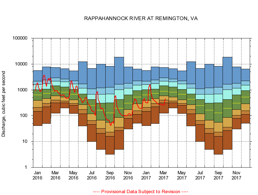
01664000
RAPPAHANNOCK RIVER AT REMINGTON, VA
|
Minimum daily flow
|
|
|
5th percentile
|
|
|
|
10th percentile
|
|
|
|
|
25th percentile
|
|
|
|
|
|
Median
|
|
|
|
|
|
|
75th percentile
|
|
|
|
|
|
|
|
90th percentile
|
|
|
|
|
|
|
|
|
95th percentile
|
|
|
|
|
|
|
|
|
|
Maximum daily flow
|
|
|
|
|
|
|
|
|
|
|
|
Years of record
|
January
|
41.6
|
147
|
213
|
389
|
640
|
1,030
|
1,610
|
2,200
|
5,560
|
|
73
|
February
|
50.0
|
220
|
299
|
464
|
728
|
1,060
|
1,740
|
2,430
|
7,690
|
|
73
|
March
|
124
|
318
|
406
|
585
|
888
|
1,440
|
2,160
|
2,950
|
7,450
|
|
73
|
April
|
197
|
318
|
376
|
531
|
815
|
1,310
|
2,050
|
2,630
|
6,680
|
|
73
|
May
|
122
|
252
|
301
|
417
|
679
|
1,040
|
1,720
|
2,260
|
5,510
|
|
73
|
June
|
40.4
|
118
|
176
|
269
|
435
|
688
|
1,150
|
1,680
|
12,300
|
|
73
|
July
|
10.1
|
46.1
|
65.1
|
120
|
248
|
422
|
684
|
1,110
|
6,810
|
|
73
|
August
|
5.00
|
21.1
|
31.9
|
66.4
|
163
|
307
|
669
|
1,190
|
9,880
|
|
73
|
September
|
3.23
|
16.1
|
23.3
|
55.4
|
129
|
315
|
703
|
1,260
|
8,240
|
|
73
|
October
|
4.90
|
26.7
|
36.1
|
85.6
|
196
|
432
|
1,020
|
1,660
|
18,800
|
|
72
|
November
|
30.7
|
79.6
|
104
|
173
|
311
|
635
|
1,170
|
1,820
|
7,790
|
|
73
|
December
|
51.4
|
114
|
155
|
288
|
534
|
941
|
1,510
|
2,210
|
6,390
|
|
73
|
|
|
|