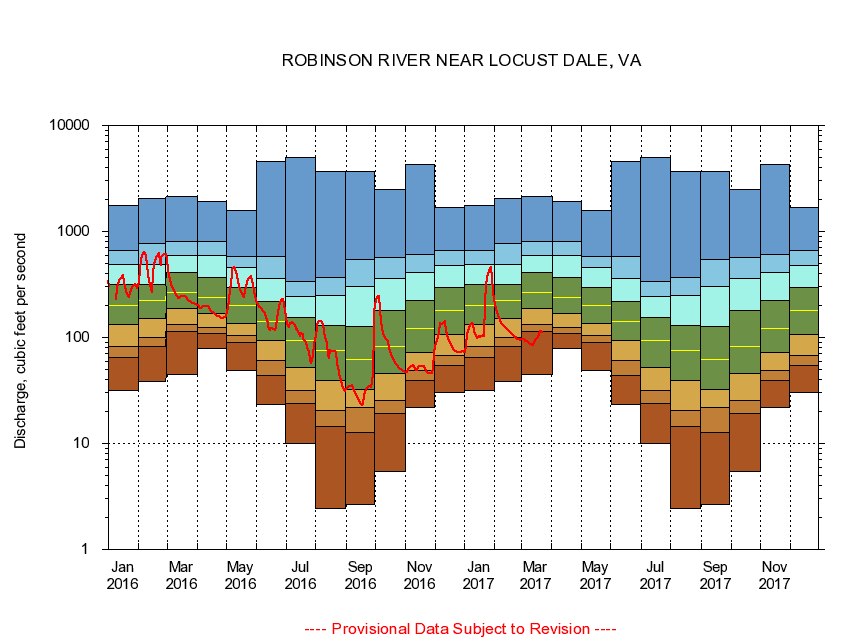
USGS - science for a changing world
Virginia DEQ

Virginia Water Science Center

 
  Duration Plot and Table of 7-Day Average Streamflow
 
01666500 ROBINSON RIVER NEAR LOCUST DALE, VA
LOCATION.--Latitude 38°19'30", Longitude 78°05'45", North American Datum of 1927,
                    Madison County, VA, Hydrologic Unit 02080103.
DRAINAGE AREA.--179 square miles.
PERIOD OF RECORD.--July 1943 to current year. Prior to October 1965, published as Robertson River near Locust Dale.
DURATION STATISTIC COMPUTATION PERIOD.--All data through September 2015.
REGULATION.--Low flow regulated by powerplant about 11 miles above station and at mill about 14 miles above station in prior years.
GAGE OPERATION.--Virginia Department of Environmental Quality - Water Division.

     Duration Plot with 7-Day Average Streamflow Conditions
Provisional Data Subject to Revision
01666500 plot. 
ROBINSON RIVER NEAR LOCUST DALE, VA
Provisional Data Subject to Revision


The current 7-day running-average value for 03/22/2017 is 110.71 cubic feet per second.

  explanation   Percentile Description Duration Plot Description 28 Day 14 Day 7 Day Daily


      Duration Table of 7-Day Average Streamflow
           
Flow values in cubic feet per second


                01666500     ROBINSON RIVER NEAR LOCUST DALE, VA

   Minimum daily flow
   5th percentile
 
   10th percentile
 
   25th percentile
 
 
   Median
 
 
   75th percentile


   90th percentile


   95th percentile


   Maximum daily flow
         
Years of record
January
31.9
65.2
82.3
132
201
314
489
659
1,750
 
72
February
38.1
82.4
101
151
225
314
484
764
2,060
 
72
March
44.3
113
134
188
267
406
598
799
2,130
 
72
April
78.6
110
125
167
238
370
593
799
1,920
 
72
May
48.6
89.5
105
136
202
298
455
577
1,590
 
72
June
23.3
43.9
61.3
93.6
142
220
358
576
4,580
 
72
July
10.0
24.1
31.6
51.6
94.4
153
245
337
4,970
 
72
August
2.46
14.4
20.5
38.9
75.4
131
249
372
3,670
 
72
September
2.67
12.8
22.0
32.4
62.2
126
301
550
3,700
 
73
October
5.49
19.0
25.7
45.9
82.5
181
360
564
2,500
 
72
November
22.0
39.6
49.0
71.7
122
222
410
607
4,320
 
72
December
30.6
54.0
67.4
107
181
294
477
656
1,680
 
72


The current 7-day running-average value for 03/22/2017 is 110.71 cubic feet per second.

---- Provisional Data Subject to Revision ----

Accessibility FOIA Privacy Policies and Notices

Take Pride in America logo USA.gov logo U.S. Department of the Interior | U.S. Geological Survey
URL: http://va.water.usgs.gov/duration_plots/htm_7/dp01666500.htm
Page Contact Information: Virginia WSC Webmaster
Page Last Modified: 6/19/2016