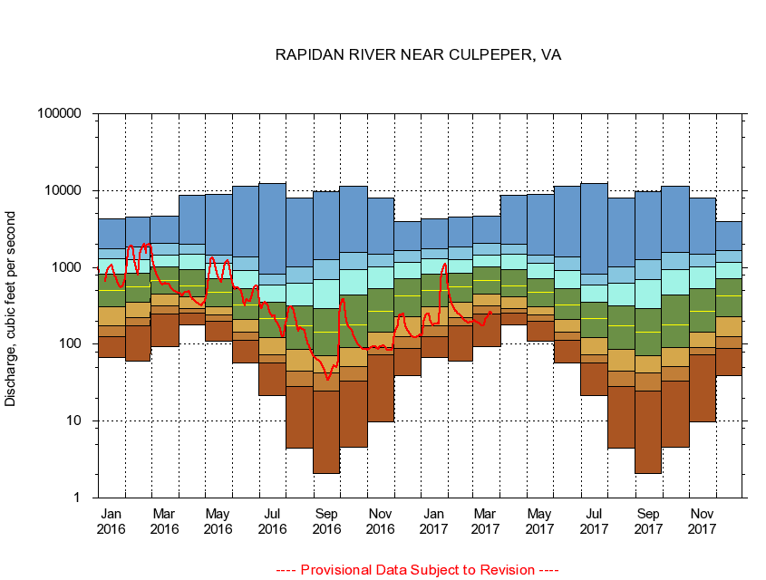
USGS - science for a changing world
Virginia DEQ

Virginia Water Science Center

 
  Duration Plot and Table of 7-Day Average Streamflow
 
01667500 RAPIDAN RIVER NEAR CULPEPER, VA
LOCATION.--Latitude 38°21'01", Longitude 77°58'31", North American Datum of 1927,
                    Culpeper County, VA, Hydrologic Unit 02080103.
DRAINAGE AREA.--468 square miles.
PERIOD OF RECORD.--October 1930 to current year. Monthly discharge only for some periods, published in WSP 1302.
DURATION STATISTIC COMPUTATION PERIOD.--All data through September 2015.
REGULATION.--Low-water flow regulated by operation of mill prior to 1977, since 1986 by a powerplant. Some diversion during summer months for irrigation.
GAGE OPERATION.--Virginia Department of Environmental Quality - Water Division.

     Duration Plot with 7-Day Average Streamflow Conditions
Provisional Data Subject to Revision
01667500 plot. 
RAPIDAN RIVER NEAR CULPEPER, VA
Provisional Data Subject to Revision


The current 7-day running-average value for 03/22/2017 is 247.14 cubic feet per second.

  explanation   Percentile Description Duration Plot Description 28 Day 14 Day 7 Day Daily


      Duration Table of 7-Day Average Streamflow
           
Flow values in cubic feet per second


                01667500     RAPIDAN RIVER NEAR CULPEPER, VA

   Minimum daily flow
   5th percentile
 
   10th percentile
 
   25th percentile
 
 
   Median
 
 
   75th percentile


   90th percentile


   95th percentile


   Maximum daily flow
         
Years of record
January
66.6
124
172
304
498
823
1,300
1,740
4,310
 
85
February
60.6
172
220
349
561
843
1,270
1,870
4,570
 
85
March
94.3
249
312
454
669
1,010
1,460
2,050
4,680
 
85
April
180
256
294
411
579
947
1,470
1,990
8,710
 
85
May
109
202
240
309
476
712
1,120
1,460
8,870
 
85
June
57.7
113
143
212
322
530
909
1,360
11,500
 
85
July
21.3
57.0
72.8
123
217
357
591
815
12,400
 
85
August
4.50
28.6
44.9
85.0
172
318
626
1,020
8,080
 
85
September
2.11
24.5
42.3
70.7
144
288
697
1,260
9,590
 
85
October
4.53
33.4
50.7
90.9
178
438
936
1,550
11,300
 
84
November
9.86
72.2
89.7
143
266
532
1,030
1,490
7,980
 
85
December
38.9
88.1
126
231
426
716
1,160
1,640
3,900
 
85


The current 7-day running-average value for 03/22/2017 is 247.14 cubic feet per second.

---- Provisional Data Subject to Revision ----

Accessibility FOIA Privacy Policies and Notices

Take Pride in America logo USA.gov logo U.S. Department of the Interior | U.S. Geological Survey
URL: http://va.water.usgs.gov/duration_plots/htm_7/dp01667500.htm
Page Contact Information: Virginia WSC Webmaster
Page Last Modified: 6/19/2016