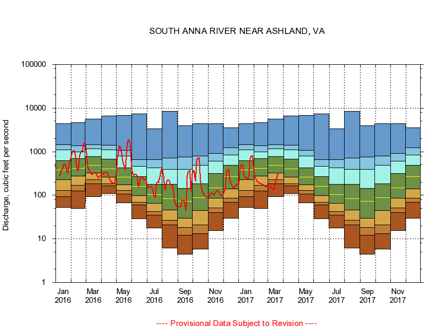
USGS - science for a changing world
Virginia DEQ

Virginia Water Science Center

 
  Duration Plot and Table of 7-Day Average Streamflow
 
01672500 SOUTH ANNA RIVER NEAR ASHLAND, VA
LOCATION.--Latitude 37°47'48", Longitude 77°32'57", North American Datum of 1927,
                    Hanover County, VA, Hydrologic Unit 02080106.
DRAINAGE AREA.--395 square miles.
PERIOD OF RECORD.--October 1930 to September 1997, June 2003 to current year.
DURATION STATISTIC COMPUTATION PERIOD.--All data through September 2007.
REGULATION.--Small diurnal fluctuation at low flow in some years caused by mills upstream from station. Since 1966, diversion upstream averaged less than 0.6 cfs. Capacity of the diversion is about 1.5 cfs.
GAGE OPERATION.--U.S. Geological Survey, Virginia Water Science Center.

     Duration Plot with 7-Day Average Streamflow Conditions
Provisional Data Subject to Revision
01672500 plot. 
SOUTH ANNA RIVER NEAR ASHLAND, VA
Provisional Data Subject to Revision


The current 7-day running-average value for 08/27/2008 is 13 cubic feet per second.

  explanation   Percentile Description Duration Plot Description 28 Day 14 Day 7 Day Daily


      Duration Table of 7-Day Average Streamflow
           
Flow values in cubic feet per second


                01672500     SOUTH ANNA RIVER NEAR ASHLAND, VA

   Minimum daily flow
   5th percentile
 
   10th percentile
 
   25th percentile
 
 
   Median
 
 
   75th percentile


   90th percentile


   95th percentile


   Maximum daily flow
         
Years of record
January
53.4
89.3
134
239
388
645
1,130
1,500
4,360
 
71
February
49.6
126
183
289
429
713
1,040
1,420
4,590
 
71
March
94.3
188
234
324
488
792
1,190
1,470
5,610
 
71
April
111
162
184
268
419
691
1,140
1,480
6,690
 
71
May
66.9
105
126
173
261
424
744
1,010
6,790
 
71
June
29.0
60.1
69.5
97.6
159
264
452
658
7,450
 
71
July
17.9
36.1
43.9
68.1
107
181
427
673
3,320
 
71
August
6.14
21.4
27.7
49.3
91.7
191
434
745
8,520
 
72
September
4.43
12.4
18.6
30.9
76.4
149
418
807
3,900
 
72
October
5.77
13.5
21.3
48.1
91.7
191
522
873
4,460
 
70
November
15.6
39.1
52.2
87.9
151
319
650
910
4,360
 
71
December
29.6
68.4
88.0
146
272
487
820
1,180
3,500
 
71


The current 7-day running-average value for 08/27/2008 is 13 cubic feet per second.

---- Provisional Data Subject to Revision ----

Accessibility FOIA Privacy Policies and Notices

Take Pride in America logo USA.gov logo U.S. Department of the Interior | U.S. Geological Survey
URL: http://va.water.usgs.gov/duration_plots/htm_7/dp01672500.htm
Page Contact Information: Virginia WSC Webmaster
Page Last Modified: 8/6/2008