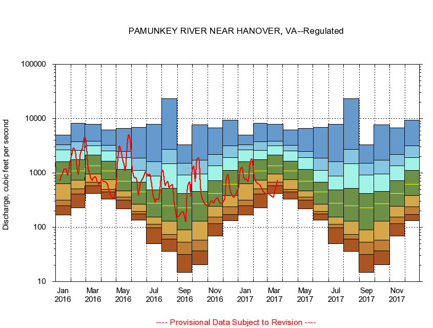
USGS - science for a changing world
Virginia DEQ

Virginia Water Science Center

 
  Duration Plot and Table of 7-Day Average Streamflow
 
01673000 PAMUNKEY RIVER NEAR HANOVER, VA
LOCATION.--Latitude 37°46'03", Longitude 77°19'57", North American Datum of 1927,
                    Hanover County, VA, Hydrologic Unit 02080106.
DRAINAGE AREA.--1,078 square miles.
PERIOD OF RECORD.--October 1941 to current year. Monthly discharge only for some periods, published in WSP 1302.
DURATION STATISTIC COMPUTATION PERIOD.--October 1941 to January 1972.
REGULATION.--Slight regulation from small mill dams upstream and by Lake Anna Power Station on North River since January 1972. Some diversion during summer months for irrigation.
GAGE OPERATION.--U.S. Geological Survey, Virginia Water Science Center.

     Duration Plot with 7-Day Average Streamflow Conditions
Provisional Data Subject to Revision
01673000 plot. 
PAMUNKEY RIVER NEAR HANOVER, VA
Provisional Data Subject to Revision


The current 7-day running-average value for 03/22/2017 is 726.14 cubic feet per second.

  explanation   Percentile Description Duration Plot Description 28 Day 14 Day 7 Day Daily


      Duration Table of 7-Day Average Streamflow
           
Flow values in cubic feet per second


                01673000     PAMUNKEY RIVER NEAR HANOVER, VA

   Minimum daily flow
   5th percentile
 
   10th percentile
 
   25th percentile
 
 
   Median
 
 
   75th percentile


   90th percentile


   95th percentile


   Maximum daily flow
         
Years of record
January
170
251
317
628
972
1,600
2,650
3,300
5,030
 
30
February
230
406
515
737
1,090
1,760
2,610
3,730
8,250
 
30
March
416
581
683
948
1,370
2,160
3,140
3,850
7,880
 
30
April
329
448
503
750
1,100
1,650
2,520
3,230
6,170
 
30
May
218
316
360
466
707
1,170
1,920
2,490
6,640
 
30
June
135
176
196
266
445
677
1,120
1,860
6,930
 
30
July
50.1
97.9
113
156
276
488
885
1,610
7,870
 
30
August
36.0
60.6
73.4
130
249
525
1,470
2,740
23,400
 
30
September
14.7
31.9
52.9
90.6
229
416
907
1,520
3,280
 
30
October
20.3
37.1
57.9
130
272
459
967
1,740
7,730
 
30
November
69.3
117
155
244
417
716
1,370
2,180
6,700
 
31
December
134
174
237
383
614
1,110
1,900
3,130
9,280
 
31


The current 7-day running-average value for 03/22/2017 is 726.14 cubic feet per second.

---- Provisional Data Subject to Revision ----

Accessibility FOIA Privacy Policies and Notices

Take Pride in America logo USA.gov logo U.S. Department of the Interior | U.S. Geological Survey
URL: http://va.water.usgs.gov/duration_plots/htm_7/dp01673000.htm
Page Contact Information: Virginia WSC Webmaster
Page Last Modified: 6/19/2016