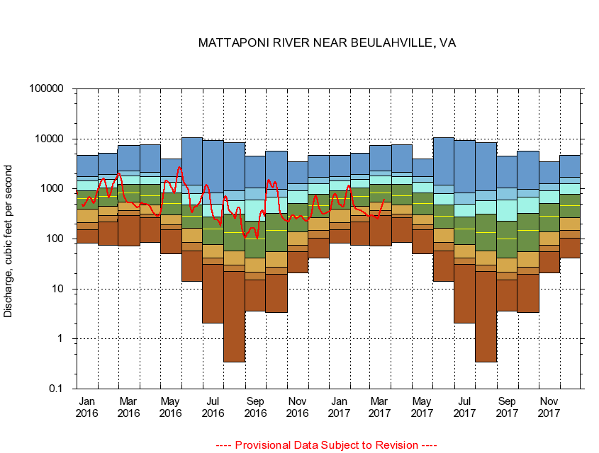
USGS - science for a changing world
Virginia DEQ

Virginia Water Science Center

 
  Duration Plot and Table of 7-Day Average Streamflow
 
01674500 MATTAPONI RIVER NEAR BEULAHVILLE, VA
LOCATION.--Latitude 37°53'16", Longitude 77°09'48", North American Datum of 1927,
                    King William County, VA, Hydrologic Unit 02080105.
DRAINAGE AREA.--602 square miles.
PERIOD OF RECORD.--September 1941 to September 1987, October 1989 to current year.
DURATION STATISTIC COMPUTATION PERIOD.--All data through September 2015.
REGULATION.--Some regulation in the past, during low flows, caused by mill on Po River.
GAGE OPERATION.--U.S. Geological Survey, Virginia Water Science Center.

     Duration Plot with 7-Day Average Streamflow Conditions
Provisional Data Subject to Revision
01674500 plot. 
MATTAPONI RIVER NEAR BEULAHVILLE, VA
Provisional Data Subject to Revision


The current 7-day running-average value for 03/22/2017 is 608.14 cubic feet per second.

  explanation   Percentile Description Duration Plot Description 28 Day 14 Day 7 Day Daily


      Duration Table of 7-Day Average Streamflow
           
Flow values in cubic feet per second


                01674500     MATTAPONI RIVER NEAR BEULAHVILLE, VA

   Minimum daily flow
   5th percentile
 
   10th percentile
 
   25th percentile
 
 
   Median
 
 
   75th percentile


   90th percentile


   95th percentile


   Maximum daily flow
         
Years of record
January
83.4
154
215
394
649
928
1,440
1,780
4,730
 
74
February
75.1
220
297
446
703
1,060
1,550
1,960
5,180
 
74
March
71.3
290
368
551
836
1,210
1,800
2,280
7,330
 
74
April
84.7
264
313
474
740
1,230
1,760
2,140
7,660
 
74
May
50.4
151
190
307
508
844
1,350
1,760
3,990
 
74
June
14.1
57.7
84.0
161
280
477
816
1,190
10,700
 
74
July
2.09
31.3
41.4
77.4
157
278
500
820
9,170
 
74
August
0.34
22.0
30.0
58.1
132
309
582
913
8,280
 
74
September
3.63
15.3
21.4
41.9
100
226
591
1,030
4,470
 
74
October
3.34
19.3
27.4
55.3
149
319
674
993
5,640
 
74
November
20.7
55.6
73.7
140
286
510
929
1,280
3,540
 
74
December
41.7
103
146
265
465
773
1,270
1,710
4,610
 
74


The current 7-day running-average value for 03/22/2017 is 608.14 cubic feet per second.

---- Provisional Data Subject to Revision ----

Accessibility FOIA Privacy Policies and Notices

Take Pride in America logo USA.gov logo U.S. Department of the Interior | U.S. Geological Survey
URL: http://va.water.usgs.gov/duration_plots/htm_7/dp01674500.htm
Page Contact Information: Virginia WSC Webmaster
Page Last Modified: 6/19/2016