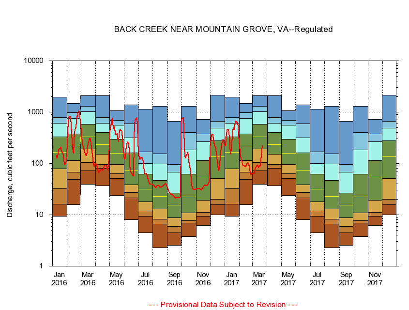
USGS - science for a changing world
Virginia DEQ

Virginia Water Science Center

 
  Duration Plot and Table of 7-Day Average Streamflow
 
02011500 BACK CREEK NEAR MOUNTAIN GROVE, VA
LOCATION.--Latitude 38°04'10", Longitude 79°53'50", North American Datum of 1927,
                    Bath County, VA, Hydrologic Unit 02080201.
DRAINAGE AREA.--134 square miles.
PERIOD OF RECORD.--October 1951 to current year.
DURATION STATISTIC COMPUTATION PERIOD.--October 1951 to October 1984.
REGULATION.--Flows regulated since October 1984 by Back Creek Lake 11.3 miles upstream and since January 1985 by Little Back Creek 14.4 miles upstream.
GAGE OPERATION.--U.S. Geological Survey, Virginia Water Science Center.

     Duration Plot with 7-Day Average Streamflow Conditions
Provisional Data Subject to Revision
02011500 plot. 
BACK CREEK NEAR MOUNTAIN GROVE, VA
Provisional Data Subject to Revision


The current 7-day running-average value for 08/27/2008 is 30 cubic feet per second.

  explanation   Percentile Description Duration Plot Description 28 Day 14 Day 7 Day Daily


      Duration Table of 7-Day Average Streamflow
           
Flow values in cubic feet per second


                02011500     BACK CREEK NEAR MOUNTAIN GROVE, VA

   Minimum daily flow
   5th percentile
 
   10th percentile
 
   25th percentile
 
 
   Median
 
 
   75th percentile


   90th percentile


   95th percentile


   Maximum daily flow
         
Years of record
January
9.46
16.3
32.9
77.9
164
332
601
786
1,940
 
33
February
15.7
49.7
68.1
115
210
377
747
980
1,490
 
33
March
39.0
71.7
104
193
330
580
1,010
1,280
2,090
 
33
April
36.6
79.7
96.4
152
235
402
604
779
2,110
 
33
May
23.6
51.2
64.1
95.3
157
299
556
690
1,060
 
33
June
8.04
21.8
27.0
38.8
74.2
161
318
587
1,380
 
33
July
4.47
9.43
11.8
18.0
31.9
61.4
99.6
169
1,150
 
33
August
2.26
6.68
8.26
13.0
22.6
46.4
96.8
152
1,290
 
33
September
2.54
4.54
5.93
8.81
15.4
26.3
67.7
95.1
655
 
33
October
3.80
6.91
7.69
10.8
22.3
61.6
184
403
1,290
 
32
November
6.26
9.46
11.1
19.3
53.9
114
264
377
720
 
33
December
10.0
15.9
20.2
51.2
137
277
482
667
2,130
 
33


The current 7-day running-average value for 08/27/2008 is 30 cubic feet per second.

---- Provisional Data Subject to Revision ----

Accessibility FOIA Privacy Policies and Notices

Take Pride in America logo USA.gov logo U.S. Department of the Interior | U.S. Geological Survey
URL: http://va.water.usgs.gov/duration_plots/htm_7/dp02011500.htm
Page Contact Information: Virginia WSC Webmaster
Page Last Modified: 8/6/2008