|
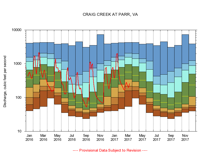
02018000
CRAIG CREEK AT PARR, VA
|
Minimum daily flow
|
|
|
5th percentile
|
|
|
|
10th percentile
|
|
|
|
|
25th percentile
|
|
|
|
|
|
Median
|
|
|
|
|
|
|
75th percentile
|
|
|
|
|
|
|
|
90th percentile
|
|
|
|
|
|
|
|
|
95th percentile
|
|
|
|
|
|
|
|
|
|
Maximum daily flow
|
|
|
|
|
|
|
|
|
|
|
|
Years of record
|
January
|
40.7
|
61.9
|
101
|
201
|
360
|
659
|
1,160
|
1,570
|
4,110
|
|
90
|
February
|
46.6
|
99.9
|
144
|
248
|
463
|
793
|
1,300
|
1,700
|
4,200
|
|
90
|
March
|
54.0
|
160
|
218
|
347
|
567
|
953
|
1,570
|
2,060
|
4,260
|
|
90
|
April
|
96.0
|
163
|
212
|
294
|
455
|
829
|
1,410
|
2,000
|
4,290
|
|
90
|
May
|
63.3
|
113
|
137
|
194
|
328
|
575
|
1,060
|
1,420
|
3,830
|
|
91
|
June
|
35.9
|
63.5
|
72.9
|
98.2
|
151
|
294
|
681
|
1,200
|
3,920
|
|
91
|
July
|
28.6
|
42.4
|
46.3
|
58.1
|
82.7
|
138
|
246
|
429
|
3,460
|
|
91
|
August
|
27.1
|
36.4
|
39.1
|
49.4
|
71.4
|
124
|
237
|
486
|
4,520
|
|
91
|
September
|
23.6
|
33.6
|
36.1
|
44.7
|
60.6
|
99.9
|
276
|
593
|
3,080
|
|
91
|
October
|
28.0
|
36.6
|
40.6
|
49.7
|
68.8
|
147
|
409
|
749
|
3,540
|
|
90
|
November
|
36.4
|
46.0
|
52.1
|
63.6
|
109
|
284
|
651
|
1,010
|
7,300
|
|
90
|
December
|
40.0
|
52.0
|
58.1
|
108
|
236
|
497
|
882
|
1,250
|
3,900
|
|
90
|
|
|
|