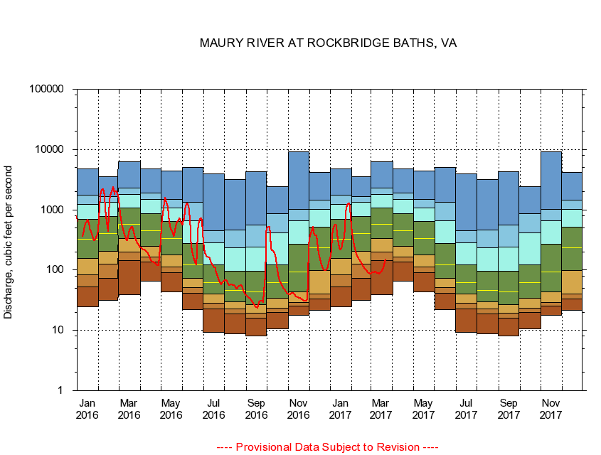
USGS - science for a changing world
Virginia DEQ

Virginia Water Science Center

 
  Duration Plot and Table of 7-Day Average Streamflow
 
02021500 MAURY RIVER AT ROCKBRIDGE BATHS, VA
LOCATION.--Latitude 37°54'26", Longitude 79°25'20", North American Datum of 1927,
                    Rockbridge County, VA, Hydrologic Unit 02080202.
DRAINAGE AREA.--329 square miles.
PERIOD OF RECORD.--October 1928 to current year. Monthly discharge only for some periods, published in WSP 1303. Prior to October 1945, published as North River at Rockbridge Baths.
DURATION STATISTIC COMPUTATION PERIOD.--All data through September 2015.
REGULATION.--Minimal regulation since 1966.
GAGE OPERATION.--U.S. Geological Survey, Virginia Water Science Center.

     Duration Plot with 7-Day Average Streamflow Conditions
Provisional Data Subject to Revision
02021500 plot. 
MAURY RIVER AT ROCKBRIDGE BATHS, VA
Provisional Data Subject to Revision


The current 7-day running-average value for 03/22/2017 is 145.86 cubic feet per second.

  explanation   Percentile Description Duration Plot Description 28 Day 14 Day 7 Day Daily


      Duration Table of 7-Day Average Streamflow
           
Flow values in cubic feet per second


                02021500     MAURY RIVER AT ROCKBRIDGE BATHS, VA

   Minimum daily flow
   5th percentile
 
   10th percentile
 
   25th percentile
 
 
   Median
 
 
   75th percentile


   90th percentile


   95th percentile


   Maximum daily flow
         
Years of record
January
24.7
52.3
82.7
158
325
693
1,230
1,730
4,800
 
87
February
31.3
73.2
124
205
406
768
1,320
1,660
3,500
 
87
March
39.6
142
202
336
579
1,060
1,800
2,310
6,320
 
87
April
66.1
136
163
246
451
862
1,470
1,900
4,720
 
87
May
43.0
90.5
114
180
333
643
1,070
1,470
4,450
 
87
June
21.9
41.1
51.9
72.8
122
278
662
1,340
5,100
 
87
July
9.24
22.7
28.0
39.9
62.0
122
282
449
3,940
 
87
August
8.71
19.0
22.6
30.1
46.1
96.1
235
460
3,200
 
87
September
8.19
16.0
19.4
26.4
44.1
95.5
239
555
4,290
 
87
October
10.5
19.6
23.6
34.0
61.4
121
411
870
2,430
 
86
November
17.9
25.4
29.1
43.7
93.7
266
650
1,010
9,250
 
87
December
21.7
33.1
39.7
98.9
237
521
1,030
1,430
4,200
 
87


The current 7-day running-average value for 03/22/2017 is 145.86 cubic feet per second.

---- Provisional Data Subject to Revision ----

Accessibility FOIA Privacy Policies and Notices

Take Pride in America logo USA.gov logo U.S. Department of the Interior | U.S. Geological Survey
URL: http://va.water.usgs.gov/duration_plots/htm_7/dp02021500.htm
Page Contact Information: Virginia WSC Webmaster
Page Last Modified: 6/19/2016