|
02024000
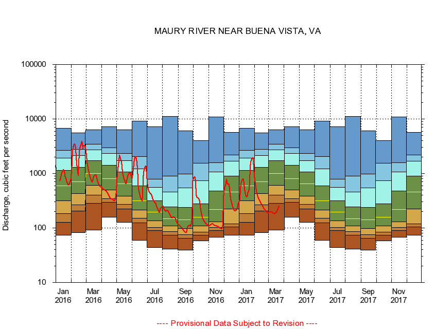
MAURY RIVER NEAR BUENA VISTA, VA
|
Minimum daily flow
|
|
|
5th percentile
|
|
|
|
10th percentile
|
|
|
|
|
25th percentile
|
|
|
|
|
|
Median
|
|
|
|
|
|
|
75th percentile
|
|
|
|
|
|
|
|
90th percentile
|
|
|
|
|
|
|
|
|
95th percentile
|
|
|
|
|
|
|
|
|
|
Maximum daily flow
|
|
|
|
|
|
|
|
|
|
|
|
Years of record
|
January
|
74.0
|
127
|
182
|
316
|
595
|
1,150
|
1,930
|
2,650
|
6,800
|
|
77
|
February
|
82.9
|
203
|
266
|
432
|
709
|
1,310
|
2,160
|
2,770
|
5,560
|
|
77
|
March
|
92.0
|
284
|
404
|
613
|
1,010
|
1,720
|
2,700
|
3,430
|
6,290
|
|
77
|
April
|
158
|
296
|
342
|
500
|
811
|
1,410
|
2,350
|
2,960
|
7,170
|
|
77
|
May
|
128
|
225
|
269
|
387
|
651
|
1,060
|
1,710
|
2,330
|
6,300
|
|
77
|
June
|
59.0
|
125
|
152
|
216
|
317
|
589
|
1,220
|
2,060
|
9,220
|
|
77
|
July
|
43.7
|
89.4
|
102
|
137
|
195
|
314
|
553
|
789
|
7,210
|
|
77
|
August
|
41.3
|
73.0
|
86.1
|
108
|
148
|
243
|
461
|
893
|
11,100
|
|
77
|
September
|
39.7
|
64.2
|
74.7
|
98.1
|
142
|
241
|
544
|
987
|
6,030
|
|
77
|
October
|
58.6
|
73.3
|
84.9
|
110
|
159
|
280
|
737
|
1,550
|
4,050
|
|
76
|
November
|
67.3
|
90.1
|
102
|
131
|
219
|
479
|
1,060
|
1,590
|
10,800
|
|
77
|
December
|
74.0
|
104
|
120
|
222
|
459
|
892
|
1,680
|
2,200
|
5,700
|
|
77
|
|
|
|