|
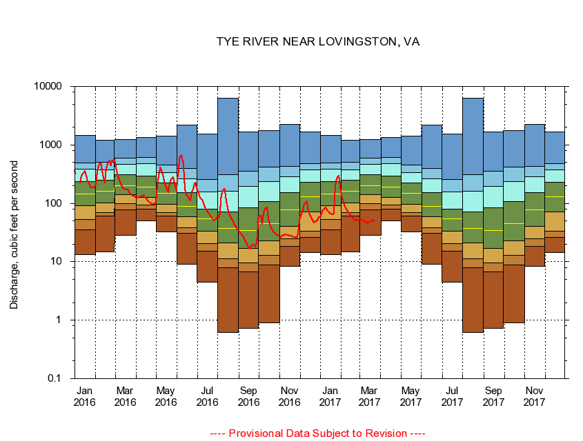
02027000
TYE RIVER NEAR LOVINGSTON, VA
|
Minimum daily flow
|
|
|
5th percentile
|
|
|
|
10th percentile
|
|
|
|
|
25th percentile
|
|
|
|
|
|
Median
|
|
|
|
|
|
|
75th percentile
|
|
|
|
|
|
|
|
90th percentile
|
|
|
|
|
|
|
|
|
95th percentile
|
|
|
|
|
|
|
|
|
|
Maximum daily flow
|
|
|
|
|
|
|
|
|
|
|
|
Years of record
|
January
|
13.3
|
35.3
|
52.7
|
90.7
|
144
|
239
|
383
|
497
|
1,460
|
|
77
|
February
|
14.7
|
60.8
|
70.2
|
102
|
161
|
252
|
378
|
503
|
1,200
|
|
77
|
March
|
28.3
|
77.4
|
97.8
|
139
|
203
|
311
|
465
|
586
|
1,250
|
|
77
|
April
|
50.7
|
78.6
|
94.4
|
126
|
188
|
292
|
476
|
602
|
1,330
|
|
77
|
May
|
32.6
|
59.9
|
69.1
|
96.6
|
148
|
225
|
339
|
452
|
1,420
|
|
77
|
June
|
9.19
|
30.5
|
38.6
|
58.5
|
89.2
|
153
|
264
|
395
|
2,190
|
|
77
|
July
|
4.47
|
15.2
|
20.4
|
33.3
|
54.0
|
80.6
|
156
|
258
|
1,550
|
|
77
|
August
|
0.61
|
7.88
|
11.4
|
20.9
|
37.3
|
71.4
|
160
|
309
|
6,250
|
|
77
|
September
|
0.73
|
6.77
|
9.51
|
16.9
|
34.2
|
85.0
|
194
|
352
|
1,680
|
|
77
|
October
|
0.91
|
8.89
|
13.0
|
22.6
|
44.6
|
108
|
238
|
422
|
1,770
|
|
76
|
November
|
8.40
|
18.4
|
24.6
|
40.1
|
77.6
|
152
|
285
|
424
|
2,250
|
|
77
|
December
|
14.3
|
25.8
|
33.1
|
71.4
|
130
|
230
|
377
|
475
|
1,660
|
|
77
|
|
|
|