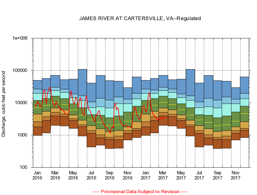
USGS - science for a changing world
Virginia DEQ

Virginia Water Science Center

 
  Duration Plot and Table of 7-Day Average Streamflow
 
02035000 JAMES RIVER AT CARTERSVILLE, VA
LOCATION.--Latitude 37°40'15", Longitude 78°05'10", North American Datum of 1927,
                    Goochland County, VA, Hydrologic Unit 02080205.
DRAINAGE AREA.--6,252 square miles.
PERIOD OF RECORD.--October 1898 to current year. Monthly discharge only for some periods, published in WSP 1303.
DURATION STATISTIC COMPUTATION PERIOD.--October 1898 to June 1982.
REGULATION.--Considerable regulation from Moomaw Lake, 230 miles upstream, as well as moderate diurnal fluctuation by powerplants above Lynchburg, 100 miles upstream. Flow augmented by summertime releases since 1982.
GAGE OPERATION.--U.S. Geological Survey, Virginia Water Science Center.

     Duration Plot with 7-Day Average Streamflow Conditions
Provisional Data Subject to Revision
02035000 plot. 
JAMES RIVER AT CARTERSVILLE, VA
Provisional Data Subject to Revision


The current 7-day running-average value for 03/22/2017 is 3611.43 cubic feet per second.

  explanation   Percentile Description Duration Plot Description 28 Day 14 Day 7 Day Daily


      Duration Table of 7-Day Average Streamflow
           
Flow values in cubic feet per second


                02035000     JAMES RIVER AT CARTERSVILLE, VA

   Minimum daily flow
   5th percentile
 
   10th percentile
 
   25th percentile
 
 
   Median
 
 
   75th percentile


   90th percentile


   95th percentile


   Maximum daily flow
         
Years of record
January
988
1,780
2,590
4,490
7,130
11,800
19,400
26,600
50,000
 
83
February
1,160
2,840
3,680
5,480
8,320
13,600
19,500
25,100
56,800
 
84
March
2,010
3,970
5,110
6,840
10,300
16,100
23,800
30,600
71,300
 
84
April
1,930
3,750
4,470
6,120
8,790
13,600
20,900
26,500
52,200
 
84
May
1,600
2,830
3,250
4,200
6,110
9,350
14,500
18,600
53,900
 
84
June
947
1,820
2,100
2,930
4,220
6,990
12,000
16,500
110,000
 
83
July
433
1,130
1,390
1,970
2,970
4,300
7,120
10,700
41,200
 
83
August
484
814
1,030
1,590
2,510
4,060
7,540
14,000
71,200
 
83
September
386
733
865
1,290
1,940
3,440
6,860
12,200
48,500
 
83
October
394
729
943
1,400
2,100
3,920
9,340
15,100
46,300
 
83
November
712
1,150
1,400
1,810
2,710
5,240
9,360
13,000
29,800
 
83
December
838
1,430
1,620
2,580
4,650
7,830
13,300
19,500
63,200
 
83


The current 7-day running-average value for 03/22/2017 is 3611.43 cubic feet per second.

---- Provisional Data Subject to Revision ----

Accessibility FOIA Privacy Policies and Notices

Take Pride in America logo USA.gov logo U.S. Department of the Interior | U.S. Geological Survey
URL: http://va.water.usgs.gov/duration_plots/htm_7/dp02035000.htm
Page Contact Information: Virginia WSC Webmaster
Page Last Modified: 6/19/2016