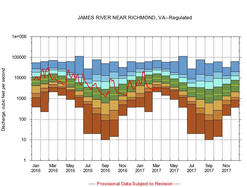
USGS - science for a changing world
Virginia DEQ

Virginia Water Science Center

 
  Duration Plot and Table of 7-Day Average Streamflow
 
02037500 JAMES RIVER NEAR RICHMOND, VA
LOCATION.--Latitude 37°33'47", Longitude 77°32'50", North American Datum of 1927,
                    Henrico County, VA, Hydrologic Unit 02080205.
DRAINAGE AREA.--6,753 square miles.
PERIOD OF RECORD.--October 1934 to current year. Gage-height records collected in vicinity of Mayo's Bridge, at mile 109.5, 1876-1956, and at mile 108.7 since 1957, are contained in reports of the National Weather Service.
DURATION STATISTIC COMPUTATION PERIOD.--October 1934 to June 1982.
REGULATION.--Regulation from upstream powerplants. Diversion through the Kanawha Canal. Flow augmented by summertime releases since June 1982.
GAGE OPERATION.--Virginia Department of Environmental Quality - Water Division.

     Duration Plot with 7-Day Average Streamflow Conditions
Provisional Data Subject to Revision
02037500 plot. 
JAMES RIVER NEAR RICHMOND, VA
Provisional Data Subject to Revision


The current 7-day running-average value for 03/22/2017 is 3212.86 cubic feet per second.

  explanation   Percentile Description Duration Plot Description 28 Day 14 Day 7 Day Daily


      Duration Table of 7-Day Average Streamflow
           
Flow values in cubic feet per second


                02037500     JAMES RIVER NEAR RICHMOND, VA

   Minimum daily flow
   5th percentile
 
   10th percentile
 
   25th percentile
 
 
   Median
 
 
   75th percentile


   90th percentile


   95th percentile


   Maximum daily flow
         
Years of record
January
395
1,110
1,810
4,190
6,750
11,700
18,900
27,700
55,500
 
48
February
229
2,100
3,230
5,150
8,590
14,000
20,700
25,800
63,400
 
48
March
2,130
3,410
4,790
6,510
9,860
15,900
24,000
30,200
72,400
 
48
April
1,420
3,270
3,840
5,450
7,910
12,900
21,500
26,900
59,100
 
48
May
902
2,380
2,730
3,610
5,820
9,090
14,700
18,400
61,800
 
48
June
381
1,190
1,450
2,370
3,660
5,970
10,500
14,900
114,000
 
47
July
20.0
537
724
1,210
2,320
3,530
5,550
8,830
27,900
 
47
August
20.0
181
348
910
1,810
3,480
7,160
14,900
76,900
 
47
September
10.0
86.8
165
619
1,340
2,820
6,520
13,300
50,300
 
47
October
14.3
91.4
275
861
1,560
3,640
9,320
19,200
60,000
 
47
November
149
509
814
1,330
2,300
5,140
9,620
12,900
32,800
 
48
December
377
846
1,140
2,150
4,470
7,810
12,800
20,300
63,500
 
48


The current 7-day running-average value for 03/22/2017 is 3212.86 cubic feet per second.

---- Provisional Data Subject to Revision ----

Accessibility FOIA Privacy Policies and Notices

Take Pride in America logo USA.gov logo U.S. Department of the Interior | U.S. Geological Survey
URL: http://va.water.usgs.gov/duration_plots/htm_7/dp02037500.htm
Page Contact Information: Virginia WSC Webmaster
Page Last Modified: 6/19/2016